IMAGES TAKEN NEAR TO
The Ridgeway, STROUD, GL6 8FW
Introduction
This page details the photographs taken nearby to The Ridgeway, GL6 8FW by members of the Geograph project.
The Geograph project started in 2005 with the aim of publishing, organising and preserving representative images for every square kilometre of Great Britain, Ireland and the Isle of Man.

There are currently over 7.5m images from over14,400 individuals and you can help contribute to the project by visiting https://www.geograph.org.uk
Image Map
Images are licensed for reuse under creativecommons.org/licenses/by-sa/2.0
Notes
- Clicking on the map will re-center to the selected point.
- The higher the marker number, the further away the image location is from the centre of the postcode.
Image Listing (6 Images Found)
Images are licensed for reuse under creativecommons.org/licenses/by-sa/2.0
Image
Details
Distance
1
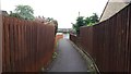
Pathway at Farmcote Close
This path provides access to housing and the nearby school.
Image: © Paul Collins
Taken: 30 May 2018
0.05 miles
2
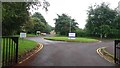
Entrance to Bussage C of E Primary School
Image: © Paul Collins
Taken: 30 May 2018
0.05 miles
3
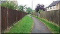
Path at Bussage
This path here passes between Farmcote Close and Stonecote Ridge. The path alignment long predates the housing, I suspect by centuries.
Image: © Paul Collins
Taken: 30 May 2018
0.08 miles
5
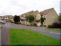
New housing estate, Bussage
This large estate can only have been built in the last few years: it straddles the edges of two Landranger maps, and is marked on sheet 163 but not on the latest edition of 162. This street is called The Old Common.
Image: © David Gruar
Taken: 25 Sep 2006
0.22 miles
6
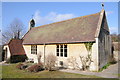
Eastcombe Church
St Augustine of Canterbury of Canterbury church in Eastcombe.
Image: © Philip Halling
Taken: 10 Mar 2012
0.22 miles