IMAGES TAKEN NEAR TO
The Valley, STROUD, GL6 8DX
Introduction
This page details the photographs taken nearby to The Valley, GL6 8DX by members of the Geograph project.
The Geograph project started in 2005 with the aim of publishing, organising and preserving representative images for every square kilometre of Great Britain, Ireland and the Isle of Man.

There are currently over 7.5m images from over14,400 individuals and you can help contribute to the project by visiting https://www.geograph.org.uk
Image Map
Images are licensed for reuse under creativecommons.org/licenses/by-sa/2.0
Notes
- Clicking on the map will re-center to the selected point.
- The higher the marker number, the further away the image location is from the centre of the postcode.
Image Listing (21 Images Found)
Images are licensed for reuse under creativecommons.org/licenses/by-sa/2.0
Image
Details
Distance
2
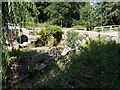
Golden Valley Lock
This lock chamber has already received considerable attention as part of the restoration effort by the Cotswold Canal Trust.
Image: © David Stowell
Taken: 30 Jan 2008
0.03 miles
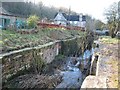
3
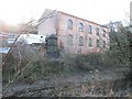
Chalford Waterworks
These buildings on the hillside above the Thames & Severn Canal once housed Chalford Waterworks. The nearest building is now used by a vehicle company however several old artefacts such as the cast cylinder have been retained.
Image: © David Stowell
Taken: 30 Jan 2008
0.03 miles
4
Across the (disused) Thames & Severn Canal
Seen walking west, towards Stroud and the Severn.
Image: © David Purchase
Taken: 20 Apr 2017
0.04 miles
7
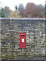
Chalford: postbox № GL6 1, High Street
An Elizabeth II-reign postbox set into a wall and facing up Coppice Hill.
Image: © Chris Downer
Taken: 13 Nov 2012
0.09 miles
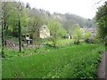
8
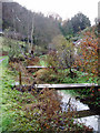
Bottom of the gardens, Chalford Bottom
The gardens on the right back on to the River Frome, and each house has its own bridge giving access to the footpath. The path was originally the towpath of the Thames and Severn Canal, now dry, which runs alongside it to the left. In the distance is an elevated section of the Gloucester-Swindon railway.
Image: © David Gruar
Taken: 19 Nov 2006
0.13 miles
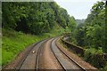
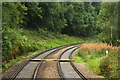
9
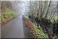
Road in the Golden Valley
Country road in the Golden Valley near Chalford on a misty autumn morning.
Image: © Philip Halling
Taken: 29 Nov 2014
0.13 miles
10
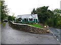
Footpath, Cowcombe Hill
The footpath runs up the short driveway approaching these two houses and then goes over the shoulder of the hill to Cowcombe Woods. The road on the right is the A419.
Image: © Nigel Mykura
Taken: 7 Oct 2011
0.15 miles