
IMAGES TAKEN NEAR TO
Wick Street, STROUD, GL6 7QW
Introduction
This page details the photographs taken nearby to Wick Street, GL6 7QW by members of the Geograph project.
The Geograph project started in 2005 with the aim of publishing, organising and preserving representative images for every square kilometre of Great Britain, Ireland and the Isle of Man.

There are currently over 7.5m images from over14,400 individuals and you can help contribute to the project by visiting https://www.geograph.org.uk
Image Map
Images are licensed for reuse under creativecommons.org/licenses/by-sa/2.0
Notes
- Clicking on the map will re-center to the selected point.
- The higher the marker number, the further away the image location is from the centre of the postcode.
Image Listing (11 Images Found)
Images are licensed for reuse under creativecommons.org/licenses/by-sa/2.0
Image
Details
Distance
1
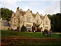
Hawkwood
An adult education college set in a former country house just outside Stroud (http://www.hawkwoodcollege.co.uk/main.htm ). Marked as 'The Grove' on the 1940s map.
Image: © David Gruar
Taken: 1 Oct 2006
0.04 miles
2

Gloucester Old Spots
Gloucestershire pigs in their home county, in the grounds of Hawkwood College in Stroud
Image: © David Gruar
Taken: 1 Oct 2006
0.05 miles

4

Cows grazing above Stroud
A quiet pastoral corner on the hill to the north of Stroud, just above Hawkwood College.
Image: © David Gruar
Taken: 1 Oct 2006
0.13 miles
5

Footpath from Painswick Old Road to Folly Lane
Eventually the driveway turns right into the grounds of Hawkwood College, and the lane continues only as a footpath.
Image: © Humphrey Bolton
Taken: 10 Jul 2017
0.15 miles


9

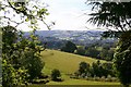
Footpath from Painswick Old Road to Folly Lane
Here the path is approaching The Plantation
Image: © Humphrey Bolton
Taken: 11 Jul 2017
0.17 miles
10

En route to Painswick
A wooded area alongside the footpath which runs from Folley Lane to the Old Painswick Road.
Image: © Sharon Loxton
Taken: 6 Jun 2008
0.24 miles