IMAGES TAKEN NEAR TO
Wick Street, STROUD, GL6 7QN
Introduction
This page details the photographs taken nearby to Wick Street, GL6 7QN by members of the Geograph project.
The Geograph project started in 2005 with the aim of publishing, organising and preserving representative images for every square kilometre of Great Britain, Ireland and the Isle of Man.

There are currently over 7.5m images from over14,400 individuals and you can help contribute to the project by visiting https://www.geograph.org.uk
Image Map
Images are licensed for reuse under creativecommons.org/licenses/by-sa/2.0
Notes
- Clicking on the map will re-center to the selected point.
- The higher the marker number, the further away the image location is from the centre of the postcode.
Image Listing (7 Images Found)
Images are licensed for reuse under creativecommons.org/licenses/by-sa/2.0
Image
Details
Distance
1
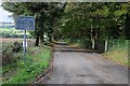
Weight Limit warning
A sign warning of a 3 tons weight limit on the bridge on this road in the Painswick Valley
Image: © Philip Halling
Taken: 11 Oct 2014
0.16 miles
2
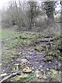
Tributary of the Painswick Stream
This small stream runs down the eastern side of the Painswick Valley into the Painswick Stream,
Image: © Terry Jacombs
Taken: 16 Mar 2012
0.18 miles
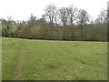
3
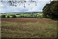
Arable land in Painswick Valley
View across the Painswick Valley to Whiteshill.
Image: © Philip Halling
Taken: 11 Oct 2014
0.19 miles
4
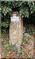
Old Milestone, Wick Street, south of Painswick
Metal plate attached to stone post by the UC road, in parish of Painswick (Stroud District), Wick Street; 50m North of The Malt House, on embankment, on East side of road. Glocester incised iron plate, erected by the Painswick turnpike trust in the 19th century.
Inscription reads:-
VIII
Miles to
Gloceſter.
Milestone Society National ID: GL_GLSDA08
Image: © M Faherty
Taken: 31 Oct 2010
0.21 miles
5
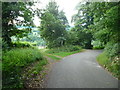
Wades Lane at the junction with the footpath from Hammonds Farm
Image: © Humphrey Bolton
Taken: 10 Jul 2017
0.22 miles
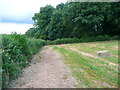
6
Valley Side, Painswick Valley
Looking south down the eastern side of the Painswick Valley south of Painswick.
Image: © Terry Jacombs
Taken: 16 Mar 2012
0.23 miles
7
Footpath from Hammonds Farm to Wades Lane
Here the path is approaching Wades Lane.
Image: © Humphrey Bolton
Taken: 10 Jul 2017
0.24 miles