IMAGES TAKEN NEAR TO
Stancombe, STROUD, GL6 7NQ
Introduction
This page details the photographs taken nearby to Stancombe, GL6 7NQ by members of the Geograph project.
The Geograph project started in 2005 with the aim of publishing, organising and preserving representative images for every square kilometre of Great Britain, Ireland and the Isle of Man.

There are currently over 7.5m images from over14,400 individuals and you can help contribute to the project by visiting https://www.geograph.org.uk
Image Map
Images are licensed for reuse under creativecommons.org/licenses/by-sa/2.0
Notes
- Clicking on the map will re-center to the selected point.
- The higher the marker number, the further away the image location is from the centre of the postcode.
Image Listing (7 Images Found)
Images are licensed for reuse under creativecommons.org/licenses/by-sa/2.0
Image
Details
Distance
1
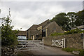
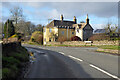
Stancombe Ash Farm
Barn at Stancombe Ash Farm
Image: © P Gaskell
Taken: Unknown
0.03 miles
2
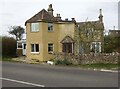
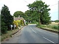
Stancombe Toll House, Bisley
Currently named "The Old Toll House" by the owners. On Bisley Road, between the junctions of Catswood Lane to the West and Stancombe Lane to the East. A more distant view is Image Originally serving the Stroud and Bisley Turnpike Trust.
Milestone Society National ID: GL.BIS02
Image: © Mr Red
Taken: 10 Apr 2022
0.04 miles
4
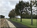
Stancombe Crossroads
A staggered crossroads near a local high point (about 260m). Looking in the general direction of the village of Bisley.
Image: © Rob Farrow
Taken: 24 Jun 2006
0.08 miles
5
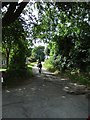
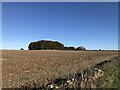
Lane to Catswood
Taken next to Stancombe Farm, the lane this horse and rider are travelling leads to Catswood.
Image: © Rob Farrow
Taken: 25 Jun 2006
0.12 miles