IMAGES TAKEN NEAR TO
Horns Road, STROUD, GL6 7LF
Introduction
This page details the photographs taken nearby to Horns Road, GL6 7LF by members of the Geograph project.
The Geograph project started in 2005 with the aim of publishing, organising and preserving representative images for every square kilometre of Great Britain, Ireland and the Isle of Man.

There are currently over 7.5m images from over14,400 individuals and you can help contribute to the project by visiting https://www.geograph.org.uk
Image Map
Images are licensed for reuse under creativecommons.org/licenses/by-sa/2.0
Notes
- Clicking on the map will re-center to the selected point.
- The higher the marker number, the further away the image location is from the centre of the postcode.
Image Listing (19 Images Found)
Images are licensed for reuse under creativecommons.org/licenses/by-sa/2.0
Image
Details
Distance
2
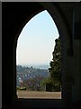
Stroud cemetery chapel, porte-cochere, Bisley Road, Stroud
Viewed facing west south west, part of the town can be seen through the arch of the porte-cochere. The weather was unseasonably warm for February.
Image: © Brian Robert Marshall
Taken: 9 Feb 2008
0.17 miles
3

Weather vane, Stroud cemetery chapel
The vane was made in 1855 by a local resident and metal worker, Henry Howell. It was recently re-gilded in 22 carat gold leaf.
Image: © Brian Robert Marshall
Taken: 9 Feb 2008
0.17 miles
4

Stroud cemetery chapel, Bisley Road, Stroud
The chapel is actually a twin chapel as can be seen in this image Image It is Victorian as is the cemetery itself, which date from the mid 1850s.
Image: © Brian Robert Marshall
Taken: 9 Feb 2008
0.17 miles
5
Stroud cemetery chapel, porte-cochere, Bisley Road, Stroud
The porte-cochere served to shelter the horse-drawn hearses while coffins were taken into one of the two chapels linked by it to the right and left. One of the pathways through the cemetery can be seen through the arch.
Image: © Brian Robert Marshall
Taken: 9 Feb 2008
0.17 miles
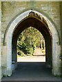
6

Stroud cemetery chapel, porte-cochere, Bisley Road, Stroud
The third of three views to the west through the porte-cochere showing even more of the often highly stylised Victorian graves. The cemetery was originally divided into three sections: one for Conformists, another for Non-Conformists and the last for paupers of the parish. This is not the paupers' section.
Image: © Brian Robert Marshall
Taken: 9 Feb 2008
0.17 miles
7
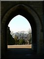
Stroud cemetery chapel, porte-cochere, Bisley Road, Stroud
The second of three views to the west through the chapel's porte-cochere. Some of the fairly ornate Victorian graves can be seen to the right. The cemetery is built on a south-facing slope with the chapel near the high point.
Image: © Brian Robert Marshall
Taken: 9 Feb 2008
0.18 miles
8
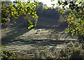
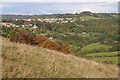
Horses at The Horns
Looking across Horns valley from the footpath between Wasa Wasa and Bisley Road Cemetery as it runs along the edge of Conygre Wood. Terracettes catch the sun, illustrating the steepness of the slope - the time is just after midday. Horns Farm is beneath the camera.
Image: © Derek Harper
Taken: 19 Oct 2007
0.18 miles
9
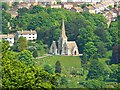
Stroud cemetery chapel, Bisley Road, Stroud
This is the chapel as viewed from Rodborough Common. More in this http://www.geograph.org.uk/photo/683826
Image: © Brian Robert Marshall
Taken: 14 May 2008
0.18 miles
10

Stroud Cemetery chapel
Stroud Cemetery chapel off Bisley Road.
Image: © Philip Halling
Taken: 10 Mar 2012
0.19 miles