IMAGES TAKEN NEAR TO
The Camp, STROUD, GL6 7HJ
Introduction
This page details the photographs taken nearby to GL6 7HJ by members of the Geograph project.
The Geograph project started in 2005 with the aim of publishing, organising and preserving representative images for every square kilometre of Great Britain, Ireland and the Isle of Man.

There are currently over 7.5m images from over14,400 individuals and you can help contribute to the project by visiting https://www.geograph.org.uk
Image Map
Images are licensed for reuse under creativecommons.org/licenses/by-sa/2.0
Notes
- Clicking on the map will re-center to the selected point.
- The higher the marker number, the further away the image location is from the centre of the postcode.
Image Listing (20 Images Found)
Images are licensed for reuse under creativecommons.org/licenses/by-sa/2.0
Image
Details
Distance
1
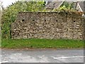
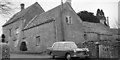
Loop-holes at The Camp?
This row of holes seems too low to support the joists for a floor, but just the right height for muskets to command the road opposite. They open up inside, too.
Image: © Mike White
Taken: 10 Sep 2008
0.02 miles
3
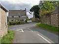
Crossroads, The Camp
Features at this crossroads include the ancient house opposite, where nothing seems level; the pierced wall on the right Image; the letterbox Image and blue plaque Image on the wall across the road from the crooked house.
Image: © Mike White
Taken: 10 Sep 2008
0.04 miles
4
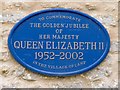
Blue Plaque, The Camp
I thought blue plaques were to commemorate something specific to the place. Perhaps they had a street party here.
Image: © Mike White
Taken: 10 Sep 2008
0.04 miles
5

Edward VII Letter Box, The Camp
This letter box is built into the house wall, and is a different design from the last one I saw.
Image: © Mike White
Taken: 10 Sep 2008
0.04 miles
6
A 1964 Morris Oxford in Calf Way, The Camp, Stroud some time around 1965
Image: © Antony Ewart Smith
Taken: Unknown
0.06 miles
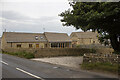
7
The Camp
New houses built from local limestone seem to have a lot less charm than their older counterparts.
Image: © Stuart Wilding
Taken: 11 Apr 2006
0.10 miles
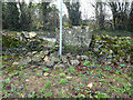
8
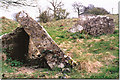
The Camp Long Barrow
This is the remains of the Chamber.
Image: © Michael Murray
Taken: 21 Dec 2008
0.17 miles
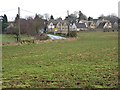
9
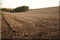
Stubble field near The Camp
A stubble field in a small valley to the north of The Camp.
Image: © Philip Halling
Taken: 27 Nov 2011
0.18 miles
10
Stone Stile, The Camp
Off Withybed Lane, on the Gloucestershire footpath MMN10. The view from the road is Image
Image: © Mr Red
Taken: 4 Jan 2022
0.18 miles