
IMAGES TAKEN NEAR TO
St. Marys Street, STROUD, GL6 6QB
Introduction
This page details the photographs taken nearby to St. Marys Street, GL6 6QB by members of the Geograph project.
The Geograph project started in 2005 with the aim of publishing, organising and preserving representative images for every square kilometre of Great Britain, Ireland and the Isle of Man.

There are currently over 7.5m images from over14,400 individuals and you can help contribute to the project by visiting https://www.geograph.org.uk
Image Map
Images are licensed for reuse under creativecommons.org/licenses/by-sa/2.0
Notes
- Clicking on the map will re-center to the selected point.
- The higher the marker number, the further away the image location is from the centre of the postcode.
Image Listing (286 Images Found)
Images are licensed for reuse under creativecommons.org/licenses/by-sa/2.0
Image
Details
Distance
1
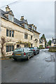
St Mary's Street
Looking along St Mary's Street. On the left is a Loveday's Cottage (17th Century) and beyond is Loveday's House (believed to have been built around 1740 for the Lovedays, a local family of clothiers, and later for a time used as the vicarage for St Mary's Church). Both are grade II listed - see www.historicengland.org.uk/listing/the-list/list-entry/1340535 and www.historicengland.org.uk/listing/the-list/list-entry/1304239 respectively.
Image: © Ian Capper
Taken: 6 Dec 2019
0.00 miles
2
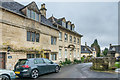
St Mary's Street
Looking along St Mary's Street. On the left is a Loveday's Cottage (17th Century) and beyond is Loveday's House (believed to have been built around 1740 for the Lovedays, a local family of clothiers, and later for a time used as the vicarage for St Mary's Church). Both are grade II listed - see www.historicengland.org.uk/listing/the-list/list-entry/1340535 and www.historicengland.org.uk/listing/the-list/list-entry/1304239 respectively.
Image: © Ian Capper
Taken: 6 Dec 2019
0.00 miles

4
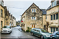
St Mary's Street
Looking along St Mary's Street. In the centre of the photo is Black Horse Cottage, the part seen here built in the late 17th/early 18th Century and now housing an art gallery, The Red Dot Gallery. Grade II listed - see www.historicengland.org.uk/listing/the-list/list-entry/1153561.
Image: © Ian Capper
Taken: 6 Dec 2019
0.01 miles
5

Victoria Street closed ahead, Painswick
Closed during roadworks in late March 2014.
Image: © Jaggery
Taken: 23 Mar 2014
0.01 miles
6
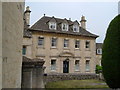
Vicarage, Painswick
The facade of this early C18 clothier's house faces across St Mary's Street onto the churchyard with its yews.
Image: © Derek Harper
Taken: 5 Jul 2006
0.01 miles
7
St Mary's Street
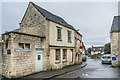
Looking along St Mary's Street. On the left is a former gents public convenience (now replaced down the alley to the left). It now houses a small studio gallery operated by local artist Rupert Aker, and is called The Loovre. To its right are the two parts of Black Horse Cottage, built in the 18th Century and the late 17th/early 18th Century and now housing an art gallery, The Red Dot Gallery. Grade II listed - see www.historicengland.org.uk/listing/the-list/list-entry/1153561.
Image: © Ian Capper
Taken: 6 Dec 2019
0.01 miles
8

Loveday's House, St Mary's Street
A classic five-bay Georgian town house of around 1740. Built by local builder John Bryan for the Lovedays, a Quaker family of some importance in Painswick as clothiers and farmers. In use as the vicarage until faisly recently.
Image: © Philip Pankhurst
Taken: 12 Jul 2006
0.01 miles
9
Golden Heart, Painswick
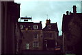
One of many historic buildings in the Cotswold village of Painswick.
http://www.britishlistedbuildings.co.uk/en-133515-golden-heart-painswick
Image: © Colin Smith
Taken: Unknown
0.02 miles
10

Three Grade II listed St Mary's Street cottages in Painswick
Left to right: Wycke Cottage, Rosemary Cottage and Rozel Cottage were each Grade II listed in 1955.
Image: © Jaggery
Taken: 23 Mar 2014
0.02 miles