IMAGES TAKEN NEAR TO
Far Westrip, STROUD, GL6 6HD
Introduction
This page details the photographs taken nearby to GL6 6HD by members of the Geograph project.
The Geograph project started in 2005 with the aim of publishing, organising and preserving representative images for every square kilometre of Great Britain, Ireland and the Isle of Man.

There are currently over 7.5m images from over14,400 individuals and you can help contribute to the project by visiting https://www.geograph.org.uk
Image Map
Images are licensed for reuse under creativecommons.org/licenses/by-sa/2.0
Notes
- Clicking on the map will re-center to the selected point.
- The higher the marker number, the further away the image location is from the centre of the postcode.
Image Listing (46 Images Found)
Images are licensed for reuse under creativecommons.org/licenses/by-sa/2.0
Image
Details
Distance
1
The Cotswold Way at Westrip
The Cotswold Way, day three 1:57pm
Image: © Ian S
Taken: 19 Apr 2013
0.01 miles
2

The Cotswold Way at Westrip
The Cotswold Way, day three 1:57pm
Image: © Ian S
Taken: 19 Apr 2013
0.03 miles
3

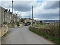
Walking down towards Far Westrip (road)
The Cotswold Way, day three 1:57pm
Image: © Ian S
Taken: 19 Apr 2013
0.03 miles
4

Narrow passage at Westrip
This is the final part of the descent to the road at Westrip from Maiden Hill.
Image: © Bill Boaden
Taken: 17 Jul 2016
0.04 miles
5

The Cotswold Way at Far Westrip (road)
The Cotswold Way, day three 1:57pm
Image: © Ian S
Taken: 19 Apr 2013
0.04 miles
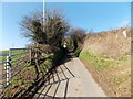
6
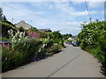
Cotswold Way, Far Westrip
The Cotswold Way National Trail https://www.nationaltrail.co.uk/cotswold-way passing through Far Westrip.
Image: © Vieve Forward
Taken: 10 Jun 2018
0.05 miles
7

Footpath above Westrip
The Cotswold Way is descending into the Frome valley, with Stroud further into the valley bottom.
Image: © Bill Boaden
Taken: 17 Jul 2016
0.05 miles
8
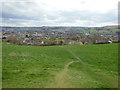
Looking over Stroud
The Cotswold Way, day three 1:54pm
Image: © Ian S
Taken: 19 Apr 2013
0.06 miles
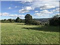
10
Field gate and stile, Sandpits Lane, Sandpits
Sandpits is a rural area between Stonehouse and Stroud.
Image: © Jaggery
Taken: 17 Feb 2013
0.07 miles