IMAGES TAKEN NEAR TO
Jubilee Road, STROUD, GL6 0NF
Introduction
This page details the photographs taken nearby to Jubilee Road, GL6 0NF by members of the Geograph project.
The Geograph project started in 2005 with the aim of publishing, organising and preserving representative images for every square kilometre of Great Britain, Ireland and the Isle of Man.

There are currently over 7.5m images from over14,400 individuals and you can help contribute to the project by visiting https://www.geograph.org.uk
Image Map
Images are licensed for reuse under creativecommons.org/licenses/by-sa/2.0
Notes
- Clicking on the map will re-center to the selected point.
- The higher the marker number, the further away the image location is from the centre of the postcode.
Image Listing (17 Images Found)
Images are licensed for reuse under creativecommons.org/licenses/by-sa/2.0
Image
Details
Distance
1
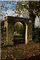
Arched entrance to a cemetery, Nailsworth
Arched entrance to a cemetery in Nailsworth. The sign on the wall of the arch warns of 'uneven ground holes, badger sets (sic) & snakes'.
Image: © Philip Halling
Taken: 8 Nov 2008
0.02 miles
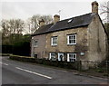
2
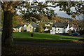
Forest Green at Nailsworth
Cottages at Forest Green above Nailsworth.
Image: © Philip Halling
Taken: 8 Nov 2008
0.03 miles
3
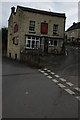
The Jovial Foresters
The Jovial Foresters pub in Nailsworth.
Image: © Philip Halling
Taken: 8 Nov 2008
0.13 miles
4
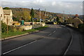
Road through Forest Green
Road through Forest Green to Nailsworth.
Image: © Philip Halling
Taken: 8 Nov 2008
0.14 miles
5
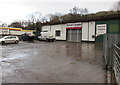
Stroud Carpets, Nailsworth
On the north side of the A46 Stroud Road. The business sells carpets, vinyls, remnants, rugs, laminates etc.
Image: © Jaggery
Taken: 20 Dec 2015
0.21 miles
6
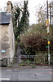
Path from Nailsworth towards Inchbrook Hill
Ascending from the west side of the A46 Stroud Road.
Image: © Jaggery
Taken: 20 Dec 2015
0.21 miles
7
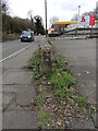
Old Milestone by A46, Whitecroft
The Milestone is located by former garage, end of wall on the side of the road. Parish of Nailsworth (Stroud District). Stone post (plate lost), Nailsworth plate design, erected by the Coldharbour Turnpike trust in the 19th Century. An earlier photograph can be found here: https://www.geograph.org.uk/photo/6663990
Inscription once read:-
Gloucester 14 / Bath 25
Milestone Society National ID: GL_BAGL25
Image: © Roadside Relics
Taken: 18 Mar 2024
0.22 miles
8
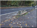
Probably milestone, A46 Nailsworth
The original location of a milestone was ST 84782 99987 (Whitecroft), which is in front of a modern (c 2000s) wood-built house. This looks to have been placed in front of what was a garage/petrol station, now industrial type shops. The holes look to be those that would hold a mileage plate.
Gloucester 14 / Bath 25
Milestone Society National ID: GL_BAGL25
Image: © Mr Red
Taken: 4 Nov 2020
0.22 miles
9
Haysdene, Nailsworth
Viewed across the A46 Stroud Road in the north of Nailsworth.
Image: © Jaggery
Taken: 20 Dec 2015
0.23 miles
10
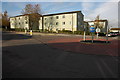
Housing association accommodation, Forest Green
Recently built housing association accommodation in Forest Green.
Image: © Philip Halling
Taken: 8 Nov 2008
0.23 miles