IMAGES TAKEN NEAR TO
Rockness Hill, STROUD, GL6 0JU
Introduction
This page details the photographs taken nearby to Rockness Hill, GL6 0JU by members of the Geograph project.
The Geograph project started in 2005 with the aim of publishing, organising and preserving representative images for every square kilometre of Great Britain, Ireland and the Isle of Man.

There are currently over 7.5m images from over14,400 individuals and you can help contribute to the project by visiting https://www.geograph.org.uk
Image Map
Images are licensed for reuse under creativecommons.org/licenses/by-sa/2.0
Notes
- Clicking on the map will re-center to the selected point.
- The higher the marker number, the further away the image location is from the centre of the postcode.
Image Listing (58 Images Found)
Images are licensed for reuse under creativecommons.org/licenses/by-sa/2.0
Image
Details
Distance
1

Stone Stile, Horsley/Nailsworth
Sitting exactly on the boundary between Horsley and Nailsworth, and the junction of Gloucestershire footpaths MHO15 & ZNA19. This is looking NW away from a u/c road called Rockness Hill (along a short enclosed path). The view from below is Image
Image: © Mr Red
Taken: 14 Jan 2022
0.03 miles
2

Stone Stile, Horsley/Nailsworth
Sitting exactly on the boundary between Horsley and Nailsworth, and the junction of Gloucestershire footpaths MHO15 & ZNA19. This is looking SE in the direction of a u/c road called Rockness Hill. The view from below is Image
Image: © Mr Red
Taken: 14 Jan 2022
0.03 miles
3
Horsley Road from the fishery
Taken on the path running through Ruskin Mill College, Nailsworth, Gloucestershire, I am at the point where the fishery abuts the market garden and looking up to Horsley Road.
Image: © Carroll Pierce
Taken: 1 Nov 2015
0.04 miles
4
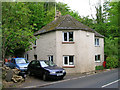
Old Toll House by Horsley Road, Nailsworth
Toll House on Horsley Road (B4058), in the parish of Nailsworth (Stroud District), Pike Cottage, GL6 0RS.
Gloucestershire County Council.
HER 2900 https://www.heritagegateway.org.uk/Gateway/Results_Single.aspx?uid=2900&resourceID=108
Surveyed
Milestone Society National ID: GL.NAI01
Image: © Alan Rosevear
Taken: 21 May 2005
0.05 miles
5
Pike Cottage, Horsley Road, Nailsworth
The location and shape of this building means that it was almost certainly a toll house and the name Pike is probably a contraction of 'turnpike'.
Image: © Chris Allen
Taken: 27 Oct 2013
0.05 miles
6
Fishery
Seems to be part of Ruskin Mill-an education establishment for those with special needs.
Image: © Bikeboy
Taken: 8 Apr 2014
0.06 miles
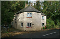
7
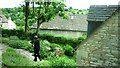
View from The Coach House
Looking down onto Rockness Hill. The Coach House was a holiday let in 2011.
Image: © Clint Mann
Taken: 13 May 2011
0.08 miles
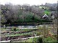
8
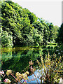
Lake at Ruskin Mill College, Nailsworth
Ruskin Mill College is an educational establishment providing a place of learning for over 80 students with special learning needs http://www.fmc.rmet.org.uk/rmc/rmc_menu1.htm It is located within former early 19th century woollen mills that were until relatively recently in a state of some decay. There are several lakes and ponds which provide a home for aquatic birds, specimen carp and trout.
Image: © Brian Robert Marshall
Taken: 7 Aug 2009
0.08 miles
9
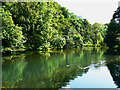
Lake at Ruskin Mill College, Nailsworth
This section of one of the valleys that run through Nailsworth is home to the Ruskin Mill College which provides an educational resource for students with particular learning needs http://www.rmet.co.uk/index.php/the_colleges/ruskin_mill/ The numerous ponds and lakes are havens for numerous waterfowl, several huge carp and brown trout.
Image: © Brian Robert Marshall
Taken: 7 Aug 2009
0.08 miles
10
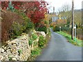
Rockness Hill, Nailsworth
The narrow road runs parallel to and west of the B4058 Old Bristol Road along the steep side of a valley.
Image: © Brian Robert Marshall
Taken: 11 Nov 2008
0.09 miles