IMAGES TAKEN NEAR TO
Stroud Road, STROUD, GL6 0BE
Introduction
This page details the photographs taken nearby to Stroud Road, GL6 0BE by members of the Geograph project.
The Geograph project started in 2005 with the aim of publishing, organising and preserving representative images for every square kilometre of Great Britain, Ireland and the Isle of Man.

There are currently over 7.5m images from over14,400 individuals and you can help contribute to the project by visiting https://www.geograph.org.uk
Image Map
Images are licensed for reuse under creativecommons.org/licenses/by-sa/2.0
Notes
- Clicking on the map will re-center to the selected point.
- The higher the marker number, the further away the image location is from the centre of the postcode.
Image Listing (147 Images Found)
Images are licensed for reuse under creativecommons.org/licenses/by-sa/2.0
Image
Details
Distance
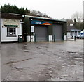
1
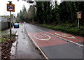
Start of the 30 zone, Stroud Road, Nailsworth
The 40mph speed limit on the A46 Stroud Road drops to 30mph.
Image: © Jaggery
Taken: 20 Dec 2015
0.02 miles
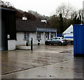
2
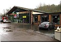
Tradeplas Building, Nailsworth
Viewed in December 2015. The former showrooms alongside the A46 Stroud Road reopened with new businesses in 2012 after refurbishment. Businesses in view include Black8Bikes, Twinkle Corner and Fifi's Hair Boutique.
Image: © Jaggery
Taken: 20 Dec 2015
0.05 miles
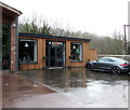
3
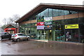
Twinkle Corner and Fifi's Hair Boutique, Nailsworth
Twinkle Corner (selling clothing & gifts for babies & toddlers) on the right and
Fifi's Hair Boutique on the left are in the Tradeplas Building facing the A46 Stroud Road.
Image: © Jaggery
Taken: 20 Dec 2015
0.05 miles
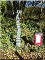
4
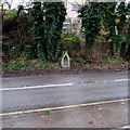
Victorian drinking fountain opposite the Tradeplas Building, Nailsworth
Alongside the A46 Stroud Road opposite the Tradeplas Building. http://www.geograph.org.uk/photo/4769941
The fountain, installed in about 1860, was Grade II listed in 1980.
Image: © Jaggery
Taken: 20 Dec 2015
0.05 miles
5
Twenty 12 hair boutique, Nailsworth
Located in the Gouldings Estate, set back from the A46 Stroud Road.
Image: © Jaggery
Taken: 20 Dec 2015
0.05 miles
6
Black8Bikes, Nailsworth
Bicycle shop located at the southeast end of the Tradeplas Building. http://www.geograph.org.uk/photo/4769941
Image: © Jaggery
Taken: 20 Dec 2015
0.06 miles
7
National Cycle Network signpost, Nailsworth
Just before the old railway track becomes a private garden of the old railway station. Cycle route 45.
Millennium Time Trail ID: tbc
Image: © Mr Red
Taken: 26 Oct 2020
0.06 miles
8
C R Signs, Nailsworth
Set back from the A46 Stroud Road, between Gouldings of Nailsworth
and Twenty 12 hair boutique, C R Signs was founded in 2008 by Craig Roberts.
Image: © Jaggery
Taken: 20 Dec 2015
0.06 miles
9
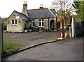
Grade II Listed Nailsworth Railway Station House
The former Nailsworth Station building is now a private house, Grade II listed in 1975. The building dates from the 1860s, at a terminus of the Stonehouse & Nailsworth Railway which opened in 1867. The ambitious intention was to continue the line to Southampton via the Cotswolds. This never happened. Indeed the Stonehouse & Nailsworth Railway was soon in financial difficulties, and was taken over by the Midland Railway in 1878.
Most of the line's revenue was from freight. After passenger services on the line ended in 1949, freight trains continued to run until the branch line closed in 1966.
Image: © Jaggery
Taken: 20 Dec 2015
0.07 miles
10
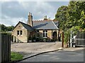
Nailsworth railway station (site), Gloucestershire
Opened in 1867 by the Stonehouse & Nailsworth Railway, very soon to become part of the Midland Railway, as the southern terminus of the line, this station closed to passengers in 1947 and completely in 1966.
View north west at the forecourt, and towards Woodchester and Stonehouse. The building, now a private residence, and platform (out of sight to the left of the building) were both well looked after when this image was taken.
Image: © Nigel Thompson
Taken: 9 Oct 2021
0.07 miles