IMAGES TAKEN NEAR TO
Snowshill Hill, MORETON-IN-MARSH, GL56 9TQ
Introduction
This page details the photographs taken nearby to GL56 9TQ by members of the Geograph project.
The Geograph project started in 2005 with the aim of publishing, organising and preserving representative images for every square kilometre of Great Britain, Ireland and the Isle of Man.

There are currently over 7.5m images from over14,400 individuals and you can help contribute to the project by visiting https://www.geograph.org.uk
Image Map (Loading...)


Getting Data...Please wait
Leaflet Map data © OpenStreetMap
Images are licensed for reuse under creativecommons.org/licenses/by-sa/2.0
Notes
- Clicking on the map will re-center to the selected point.
- The higher the marker number, the further away the image location is from the centre of the postcode.
Image Listing (6 Images Found)
Images are licensed for reuse under creativecommons.org/licenses/by-sa/2.0
Image
Details
Distance
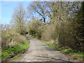
1
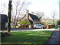
Smallthorns Farm
This view is from the minor road that runs past the farm. The footpath to Buckle Street goes through the farm.
Image: © Michael Dibb
Taken: 15 Nov 2009
0.03 miles
2
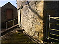
Smallthorns Farm building
Showing an OS benchmark on the corner by the footpath gate.
Image: © Liz Stone
Taken: 4 Feb 2013
0.03 miles
3
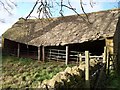
In need of some maintenance
This animal shelter is at the rear of Smallthorns Farm, seen from the footpath to Buckle Street.
Image: © Michael Dibb
Taken: 15 Nov 2009
0.03 miles
4
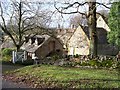
Cottages near Smallthorns Farm
At the end of the driveway to Bourton Far Hill Farm, these two cottages are alongside the minor road.
Image: © Michael Dibb
Taken: 15 Nov 2009
0.06 miles
6
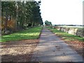
Driveway to Bourton Far Hill Farm
A bridleway runs down the driveway. This view is looking west towards Smallthorns.
Image: © Michael Dibb
Taken: 15 Nov 2009
0.18 miles