IMAGES TAKEN NEAR TO
MORETON-IN-MARSH, GL56 9QR
Introduction
This page details the photographs taken nearby to GL56 9QR by members of the Geograph project.
The Geograph project started in 2005 with the aim of publishing, organising and preserving representative images for every square kilometre of Great Britain, Ireland and the Isle of Man.

There are currently over 7.5m images from over14,400 individuals and you can help contribute to the project by visiting https://www.geograph.org.uk
Image Map
Images are licensed for reuse under creativecommons.org/licenses/by-sa/2.0
Notes
- Clicking on the map will re-center to the selected point.
- The higher the marker number, the further away the image location is from the centre of the postcode.
Image Listing (9 Images Found)
Images are licensed for reuse under creativecommons.org/licenses/by-sa/2.0
Image
Details
Distance
1
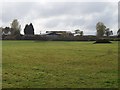
Middle Ditchford Farm
This view is from near Paddle Brook.
Image: © Michael Dibb
Taken: 21 Oct 2009
0.03 miles
2
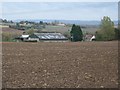
Middle Ditchford Farm
The farm seen from the minor road running between Paxford and Ditchford on Fosse. Stretton-on-Fosse in the background.
Image: © Michael Dibb
Taken: 21 Oct 2009
0.04 miles
3
Middle Ditchford
View across a crop of beans to Middle Ditchford.
Image: © Philip Halling
Taken: 6 Sep 2015
0.06 miles
4

Across the field
The crop is growing well in this field near Middle Ditchford Farm. The line of the footpath has been indicated by the track of the tractor.
Image: © Michael Dibb
Taken: 17 May 2010
0.13 miles
5
Driveway to Middle Ditchford Farm
Seen from the minor road.
Image: © Michael Dibb
Taken: 17 May 2010
0.13 miles
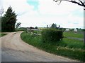
6
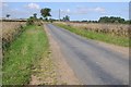
Country road to Paxford
Country road crossing Ditchford Hill en route to Paxford.
Image: © Philip Halling
Taken: 6 Sep 2015
0.16 miles
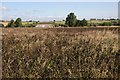
7
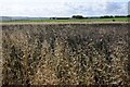
Farmland on Ditchford Hill
View to the south over farmland from the road on Ditchford Hill to the south of the village of Stretton-on-Fosse.
Image: © Philip Halling
Taken: 6 Sep 2015
0.21 miles
8
Bridges over Paddle Brook
The older footbridge (nearest camera) and the newer vehicle bridge over Paddle Brook. The brook is the county boundary here, Gloucestershire this side, Warwickshire the other side.
Image: © Michael Dibb
Taken: 21 Oct 2009
0.24 miles
9
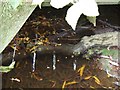
Under the bridge
Sunlight, through the gaps in the railway sleepers making up the bridge decking, on the surface of Paddle Brook.
Image: © Michael Dibb
Taken: 21 Oct 2009
0.24 miles