IMAGES TAKEN NEAR TO
Cornflower Road, MORETON-IN-MARSH, GL56 9PR
Introduction
This page details the photographs taken nearby to Cornflower Road, GL56 9PR by members of the Geograph project.
The Geograph project started in 2005 with the aim of publishing, organising and preserving representative images for every square kilometre of Great Britain, Ireland and the Isle of Man.

There are currently over 7.5m images from over14,400 individuals and you can help contribute to the project by visiting https://www.geograph.org.uk
Image Map (Loading...)


Getting Data...Please wait
Leaflet Map data © OpenStreetMap
Images are licensed for reuse under creativecommons.org/licenses/by-sa/2.0
Notes
- Clicking on the map will re-center to the selected point.
- The higher the marker number, the further away the image location is from the centre of the postcode.
Image Listing (30 Images Found)
Images are licensed for reuse under creativecommons.org/licenses/by-sa/2.0
Image
Details
Distance
1
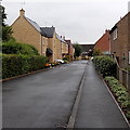
Nursery Close, Moreton-in-Marsh
A cul-de-sac of recently-built houses at the NE edge of Moreton-in-Marsh.
Image: © Jaggery
Taken: 5 Aug 2014
0.14 miles
2
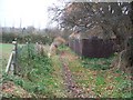
Footpath at Moreton
The footpath from Moreton-in-Marsh railway station to the A44 passes along this track at the rear of houses before turning sharp right towards the main road.
Image: © Michael Dibb
Taken: 24 Nov 2009
0.14 miles
4
Matcon House
Seen in 2010, only the building on the right remains, the rest is now residential development.
Image: © Wayland Smith
Taken: 30 May 2010
0.20 miles
5
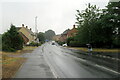
A wet London Road heading east out of Moreton-in-Marsh
Image: © Roy Hughes
Taken: 26 Jul 2022
0.20 miles
6
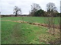
Over the stream
A public footpath passes over the footbridge at Moreton-in-Marsh railway station. The path continues across this field towards the A44.
Image: © Michael Dibb
Taken: 24 Nov 2009
0.20 miles
7
Road to the coach parking area near Moreton-in-Marsh
A white on green sign points towards the coach parking area which is located outside Moreton, alongside the road to Todenham. Despite the many dozens of tourist coaches that arrive in the town, there is no centrally located coach station in Moreton-in-Marsh. There are dropping-off and boarding points in the busy town centre. While awaiting departure from Moreton, coaches can use the parking area ahead.
Image: © Jaggery
Taken: 5 Aug 2014
0.20 miles
8
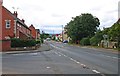
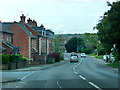
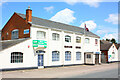
London Road (A44), Moreton-in-Marsh, Glos
London Road is one of the main roads in the town and forms part of the A44. This view is looking in the direction of the town centre. The road on the left, in the foreground, is Evenlode Road.
Image: © P L Chadwick
Taken: 7 Sep 2013
0.21 miles
9
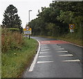
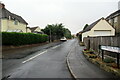
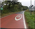
NE boundary of Moreton-in-Marsh
The National Speed Limit along the road from Todenham reduces to 30mph.
Image: © Jaggery
Taken: 5 Aug 2014
0.21 miles