IMAGES TAKEN NEAR TO
Chantry Gardens, MORETON-IN-MARSH, GL56 9AP
Introduction
This page details the photographs taken nearby to Chantry Gardens, GL56 9AP by members of the Geograph project.
The Geograph project started in 2005 with the aim of publishing, organising and preserving representative images for every square kilometre of Great Britain, Ireland and the Isle of Man.

There are currently over 7.5m images from over14,400 individuals and you can help contribute to the project by visiting https://www.geograph.org.uk
Image Map
Images are licensed for reuse under creativecommons.org/licenses/by-sa/2.0
Notes
- Clicking on the map will re-center to the selected point.
- The higher the marker number, the further away the image location is from the centre of the postcode.
Image Listing (74 Images Found)
Images are licensed for reuse under creativecommons.org/licenses/by-sa/2.0
Image
Details
Distance
1
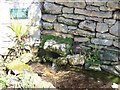
Restored trough
A drinking trough behind the church in Bourton-on-the-Hill. The plaque records that "This old drinking trough was renovated in 1996 with money awarded for winning the Bledisloe Cup for the best kept village in Gloucestershire in 1995".
Image: © Michael Dibb
Taken: 13 Apr 2010
0.02 miles
2
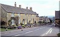
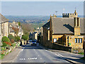
Bourton on the Hill again - Gloucestershire
The village stands astride the A44 to the west of Moreton in Marsh Image and the church of St Laurence has its origins in the time of the Normans. It is also the last resting place of the philanthropist Samuel Wilson Warneford and has a rare survival in the form of a Winchester Bushel and Peck. In 1587 Winchester received a new set of weights and measures and these, being so accurate, were adopted throughout the kingdom – the example in the church was used in settling disputes over tithes. The village also has to show Bourton House, rebuilt in 1700 and a tithe barn of 1570. Time photo taken not available.
Image: © Martin Richard Phelan
Taken: Unknown
0.03 miles
3
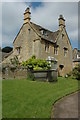
House in Bourton-on-the-Hill
House overlooking Bourton-on-the-Hill churchyard.
Image: © Philip Halling
Taken: 16 Aug 2009
0.03 miles
4
Parish Church
Dedicated to St Lawrence
Image: © Dennis Turner
Taken: 25 Nov 2004
0.03 miles
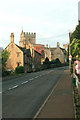
5
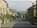
Bourton-on-the-Hill, the A44 facing east.
The 1:11, as signed, descent through this delightful Cotswold village.
Image: © Tony Wheeler
Taken: 27 Feb 2003
0.03 miles
7
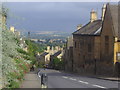
View across The Cotswolds from Bourton on the Hill
It's probably possible to see three counties from here, the border with Warwickshire is a few miles to the east and then Oxfordshire a couple of miles beyond.
Image: © David Howard
Taken: 21 Aug 2012
0.03 miles
8
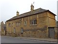
Bourton On The Hill-Sunday School Building
Dating from 1828.
Image: © Ian Rob
Taken: 21 Mar 2019
0.03 miles
9
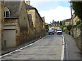
Road closure on the A44, Bourton-on-the-Hill
Image: © JThomas
Taken: 15 Apr 2023
0.03 miles
10
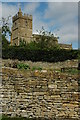
Cotswold stone wall, Bourton-on-the-Hill
Uses of the mellow Cotswold oolitic limestone include drystone walls and Bourton-on-the-Hill church seen here on the background.
Image: © Philip Halling
Taken: 16 Aug 2009
0.04 miles