IMAGES TAKEN NEAR TO
Bourton On The Hill, MORETON-IN-MARSH, GL56 9AH
Introduction
This page details the photographs taken nearby to GL56 9AH by members of the Geograph project.
The Geograph project started in 2005 with the aim of publishing, organising and preserving representative images for every square kilometre of Great Britain, Ireland and the Isle of Man.

There are currently over 7.5m images from over14,400 individuals and you can help contribute to the project by visiting https://www.geograph.org.uk
Image Map
Images are licensed for reuse under creativecommons.org/licenses/by-sa/2.0
Notes
- Clicking on the map will re-center to the selected point.
- The higher the marker number, the further away the image location is from the centre of the postcode.
Image Listing (75 Images Found)
Images are licensed for reuse under creativecommons.org/licenses/by-sa/2.0
Image
Details
Distance
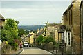
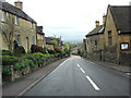
1
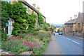
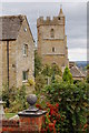
Bourton-on-the-Hill
Looking down the hill towards the centre of the village. The road is the A44.
Image: © Trevor Harris
Taken: 26 Jul 2014
0.01 miles

7
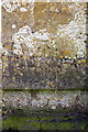
Benchmark on St Lawrence Church's tower
Ordnance Survey cut mark benchmark described on the Bench Mark Database at http://www.bench-marks.org.uk/bm58064
Image: © Roger Templeman
Taken: 7 Jun 2014
0.02 miles
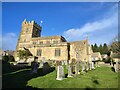
8
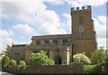
St Laurence's church in Bourton-on-the-Hill, Gloucestershire
Image: © Roger Davies
Taken: 19 Sep 2010
0.02 miles
9

Interior of Bourton-on-the-Hill Church
View along the nave to the chancel and altar of St Lawrence's church, Bourton-on-the-Hill.
Image: © Philip Halling
Taken: 16 Aug 2009
0.02 miles
10
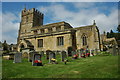
Bourton-on-the-Hill Church
Bourton-on-the-Hill church is dedicated to St Lawrence.
Image: © Philip Halling
Taken: 16 Aug 2009
0.02 miles