IMAGES TAKEN NEAR TO
Broadwell, MORETON-IN-MARSH, GL56 0YE
Introduction
This page details the photographs taken nearby to GL56 0YE by members of the Geograph project.
The Geograph project started in 2005 with the aim of publishing, organising and preserving representative images for every square kilometre of Great Britain, Ireland and the Isle of Man.

There are currently over 7.5m images from over14,400 individuals and you can help contribute to the project by visiting https://www.geograph.org.uk
Image Map (Loading...)


Getting Data...Please wait
Leaflet Map data © OpenStreetMap
Images are licensed for reuse under creativecommons.org/licenses/by-sa/2.0
Notes
- Clicking on the map will re-center to the selected point.
- The higher the marker number, the further away the image location is from the centre of the postcode.
Image Listing (5 Images Found)
Images are licensed for reuse under creativecommons.org/licenses/by-sa/2.0
Image
Details
Distance
1
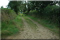
Track opposite Sydenham Farm
It's harvested time for farmers and a grain trailer can be seen at the end of this track opposite Sydenham Farm, near Oddington.
Image: © Philip Halling
Taken: 16 Aug 2009
0.14 miles
2
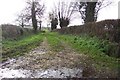
Track into fields near Sydenham Farm
Image: © Jonathan Billinger
Taken: 5 Dec 2006
0.17 miles
3

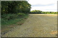
Farm track
Near Sydenham Farm.
Image: © Jennifer Luther Thomas
Taken: 18 Nov 2006
0.20 miles
5
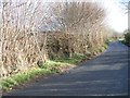
Start of the footpath
From the minor road between Broadwell and Lower Oddington, the sign marks the start of the footpath.
Image: © Michael Dibb
Taken: 25 Nov 2009
0.24 miles