IMAGES TAKEN NEAR TO
Kitebrook, MORETON-IN-MARSH, GL56 0RN
Introduction
This page details the photographs taken nearby to Kitebrook, GL56 0RN by members of the Geograph project.
The Geograph project started in 2005 with the aim of publishing, organising and preserving representative images for every square kilometre of Great Britain, Ireland and the Isle of Man.

There are currently over 7.5m images from over14,400 individuals and you can help contribute to the project by visiting https://www.geograph.org.uk
Image Map (Loading...)


Getting Data...Please wait
Leaflet Map data © OpenStreetMap
Images are licensed for reuse under creativecommons.org/licenses/by-sa/2.0
Notes
- Clicking on the map will re-center to the selected point.
- The higher the marker number, the further away the image location is from the centre of the postcode.
Image Listing (19 Images Found)
Images are licensed for reuse under creativecommons.org/licenses/by-sa/2.0
Image
Details
Distance
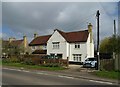
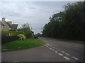
3
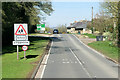
Kitebrook
A village on the A44 just on the Warwickshire side of the border with Oxfordshire.
Image: © S Parish
Taken: 27 Sep 2006
0.03 miles
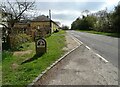
7
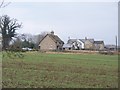
Kitebrook Farm
Seen from the field edge.
Image: © Michael Dibb
Taken: 25 Jan 2010
0.07 miles
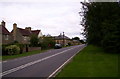
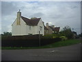
10
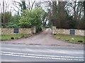
Entrance to Kitebrook House
Seen from the opposite side of the A44. Kitebrook House is now a preparatory school.
Image: © Michael Dibb
Taken: 25 Jan 2010
0.07 miles