IMAGES TAKEN NEAR TO
Chapel Lane, MORETON-IN-MARSH, GL56 0QR
Introduction
This page details the photographs taken nearby to Chapel Lane, GL56 0QR by members of the Geograph project.
The Geograph project started in 2005 with the aim of publishing, organising and preserving representative images for every square kilometre of Great Britain, Ireland and the Isle of Man.

There are currently over 7.5m images from over14,400 individuals and you can help contribute to the project by visiting https://www.geograph.org.uk
Image Map
Images are licensed for reuse under creativecommons.org/licenses/by-sa/2.0
Notes
- Clicking on the map will re-center to the selected point.
- The higher the marker number, the further away the image location is from the centre of the postcode.
Image Listing (65 Images Found)
Images are licensed for reuse under creativecommons.org/licenses/by-sa/2.0
Image
Details
Distance
1
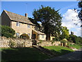
Longborough
The natural colour of these Cotswold stone cottages in Charlesway shows up nicely in the sun.
Image: © David Stowell
Taken: 24 Sep 2006
0.04 miles
4

St James's church, Longborough: Knight effigy (detail 1)
The recumbent effigy of an unnamed Knight in armour, dated c.1325.
Image: © Mike Searle
Taken: 9 Apr 2014
0.06 miles
5
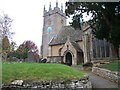
St James' church, Longborough
Seen from the gateway.
Image: © Michael Dibb
Taken: 8 Nov 2009
0.06 miles
6

St James's church, Longborough: Leigh monument (detail 2)
Sir William Leigh (†1631), his wife and children.
Image: © Mike Searle
Taken: 9 Apr 2014
0.06 miles
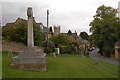
7
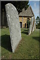
Gravestones, Longborough churchyard
Weathered gravestones in Longborough churchyard.
Image: © Philip Halling
Taken: 16 Aug 2009
0.06 miles
8

St James's church, Longborough: Knight effigy (detail 2)
The recumbent effigy of an unnamed Knight in armour, dated c.1325.
Image: © Mike Searle
Taken: 9 Apr 2014
0.06 miles
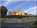
9
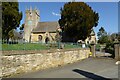
Longborough church
Longborough church is dedicated to St James and dates from the 13th century. The church is Grade I listed, see: https://historicengland.org.uk/listing/the-list/list-entry/1089762?section=official-list-entry
Image: © Philip Halling
Taken: 20 Apr 2023
0.06 miles
10
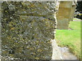
Ordnance Survey Cut Mark
This OS cut mark can be found on the SW angle of the Church of St James. It marks a point 175.2100m above mean sea level.
Image: © Adrian Dust
Taken: 27 Jun 2015
0.06 miles