IMAGES TAKEN NEAR TO
The Curfew, Oxford Street, MORETON-IN-MARSH, GL56 0LE
Introduction
This page details the photographs taken nearby to The Curfew, Oxford Street, GL56 0LE by members of the Geograph project.
The Geograph project started in 2005 with the aim of publishing, organising and preserving representative images for every square kilometre of Great Britain, Ireland and the Isle of Man.

There are currently over 7.5m images from over14,400 individuals and you can help contribute to the project by visiting https://www.geograph.org.uk
Image Map
Images are licensed for reuse under creativecommons.org/licenses/by-sa/2.0
Notes
- Clicking on the map will re-center to the selected point.
- The higher the marker number, the further away the image location is from the centre of the postcode.
Image Listing (454 Images Found)
Images are licensed for reuse under creativecommons.org/licenses/by-sa/2.0
Image
Details
Distance
1

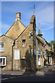
Restoration work on the Curfew Tower
The origin & function of this 16th century Grade II listed https://www.britishlistedbuildings.co.uk/101341693-curfew-tower-moreton-in-marsh building are fully and eloquently described in Image
Image: © Richard Law
Taken: 14 Aug 2017
0.00 miles
2
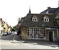
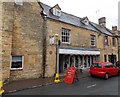
Sue Ryder Leckhampton Hospice shop, Moreton-in-Marsh
High Street charity shop on the corner of Oxford Street.
Image: © Jaggery
Taken: 18 Sep 2018
0.00 miles
3
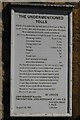
The 'undermentioned tolls'
A list of tolls in Moreton-in-Marsh from the mid-18th century.
Image: © Philip Halling
Taken: 20 Apr 2023
0.00 miles
4

OS benchmark, Moreton-in-Marsh curfew tower
An OS cutmark on a quoinstone at the base of the Curfew Tower so well described in Image It was levelled in 1969 at 127.83m above Ordnance Datum Newlyn.
Image: © Richard Law
Taken: 14 Aug 2017
0.01 miles
5
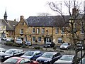
Curfew Tower
Between 1633 and 1860, the bell on the 16th Century 'Curfew Tower' was tolled morning and evening paid for by a bequest from Sir Robert Fry who had been lost when returning to the town on a foggy day.
Image: © John M
Taken: 15 Feb 2013
0.01 miles
6
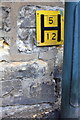
Benchmark and hydrant sign on Toll Tower
Ordnance Survey cut mark benchmark described on the Bench Mark Database at http://www.bench-marks.org.uk/bm68644
Image: © Roger Templeman
Taken: 27 Jun 2015
0.01 miles
7
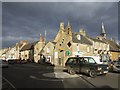
Tower displaying list of toll charges, High Street
There is an OS benchmark Image on the tower left of the lamppost. The tower is at the junction of High Street (A429) and Oxford Street (A44)
Image: © Roger Templeman
Taken: 27 Jun 2015
0.01 miles
8
White Hart Royal Hotel
The hotel has been renovated since Image with a new sign and Victorian coat of arms over the doorImage I am not sure why anyone would feel this enchanced the look of the Grade II listed building.
Image: © John M
Taken: 16 Feb 2013
0.01 miles
9
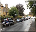
Market day bus stop in Moreton-in-Marsh
A temporary bus stop is in place today, a Tuesday, market day in Moreton-in-Marsh.
The location is Oxford Street near the corner of High Street. The red car is parked outside Allium florist.
Image: © Jaggery
Taken: 5 Aug 2014
0.01 miles
10
Oxford Street traffic in Moreton-in-Marsh
Cars queue at the High Street junction on a Tuesday, market day in Moreton-in-Marsh.
Image: © Jaggery
Taken: 5 Aug 2014
0.01 miles