IMAGES TAKEN NEAR TO
Merlin Close, MORETON-IN-MARSH, GL56 0HL
Introduction
This page details the photographs taken nearby to Merlin Close, GL56 0HL by members of the Geograph project.
The Geograph project started in 2005 with the aim of publishing, organising and preserving representative images for every square kilometre of Great Britain, Ireland and the Isle of Man.

There are currently over 7.5m images from over14,400 individuals and you can help contribute to the project by visiting https://www.geograph.org.uk
Image Map
Images are licensed for reuse under creativecommons.org/licenses/by-sa/2.0
Notes
- Clicking on the map will re-center to the selected point.
- The higher the marker number, the further away the image location is from the centre of the postcode.
Image Listing (20 Images Found)
Images are licensed for reuse under creativecommons.org/licenses/by-sa/2.0
Image
Details
Distance
1

Ex Runway 7th Avenue.
Fire Fighters undergoing training with their High Volume Pumps.
Image: © John Holmes
Taken: 6 Dec 2005
0.13 miles
2
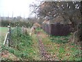
Footpath at Moreton
The footpath from Moreton-in-Marsh railway station to the A44 passes along this track at the rear of houses before turning sharp right towards the main road.
Image: © Michael Dibb
Taken: 24 Nov 2009
0.20 miles
3
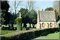
Moreton-in-Marsh New Cemetery
Lodge in Moreton-In-Marsh New Cemetery at Mosedale.
Image: © David Dixon
Taken: 4 Apr 2023
0.20 miles
4
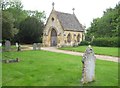
Moreton-in-Marsh: New Cemetery Chapel
The New Cemetery is on the south side of the A44 London Road. One area in the cemetery has been set aside for Image
Image: © Nigel Cox
Taken: 30 May 2015
0.20 miles

6
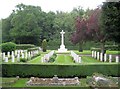
Moreton-in-Marsh: New Cemetery War Graves section
One part of the New Cemetery has an area, Section K, dedicated to War Graves. This contains the graves of 46 airmen from the very close-by former RAF airbase. It is managed by the Commonwealth War Graves Commission, with the box hedges surrounding it in immaculately sharp order.
Image: © Nigel Cox
Taken: 30 May 2015
0.21 miles
7
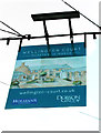
Wellington Court (the former Wellington Inn) (2) - sign, London Road, Moreton-in-Marsh, Glos
The former pub's sign has been used as a sign for the new residential conversion. The other side is different.
Image
Image
Image: © P L Chadwick
Taken: 7 Sep 2013
0.22 miles
8
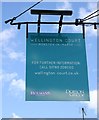
Wellington Court (the former Wellington Inn) (3) - sign, London Road, Moreton-in-Marsh, Glos
The former pub's sign has been used as a sign for the new residential conversion. The other side is different.
Image
Image
Image: © P L Chadwick
Taken: 7 Sep 2013
0.22 miles
9
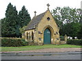
Chapel for the cemetery at Moreton-in-Marsh
Image: © Sarah Charlesworth
Taken: 13 Aug 2010
0.22 miles
10
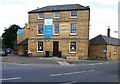
Wellington Court (the former Wellington Inn) (1), London Road, Moreton-in-Marsh, Glos
This Grade II listed building stands on the corner of London Road and Evenlode Road. Until very recently it was the Wellington Inn. According to the listing it was built around 1835. In September 2012 Cotswold District Council granted permission for its conversion into six flats and for a new two bedroom building to be built in the car park. It can be seen in use as a pub in this photograph from July 2010 by Michael Dibb:- Image
The pub used to sell the famous Hook Norton ales and was probably the last pub in the town not in the High Street area. The conversion work appears to be nearing completion and the building is now known as Wellington Court.
Image
Image
Image: © P L Chadwick
Taken: 7 Sep 2013
0.22 miles