IMAGES TAKEN NEAR TO
Lawns Park, STROUD, GL5 5PP
Introduction
This page details the photographs taken nearby to Lawns Park, GL5 5PP by members of the Geograph project.
The Geograph project started in 2005 with the aim of publishing, organising and preserving representative images for every square kilometre of Great Britain, Ireland and the Isle of Man.

There are currently over 7.5m images from over14,400 individuals and you can help contribute to the project by visiting https://www.geograph.org.uk
Image Map (Loading...)


Getting Data...Please wait
Leaflet Map data © OpenStreetMap
Images are licensed for reuse under creativecommons.org/licenses/by-sa/2.0
Notes
- Clicking on the map will re-center to the selected point.
- The higher the marker number, the further away the image location is from the centre of the postcode.
Image Listing (40 Images Found)
Images are licensed for reuse under creativecommons.org/licenses/by-sa/2.0
Image
Details
Distance
3
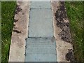
Lower view of Memorial plates at Old Woodchester Church
Same plaques as other photo, but lower view.
Image: © Michael Oram
Taken: 8 Aug 2008
0.10 miles
4
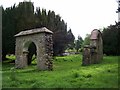
Ruins of Old Woodchester Church
New Church built nearby in the 1800's
Image: © Michael Oram
Taken: 8 Aug 2008
0.11 miles
5
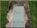
Memorial plates Old Woodchester Church
These plaques may have been added later as the original inscriptions wore out
Image: © Michael Oram
Taken: 8 Aug 2008
0.11 miles
6
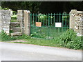
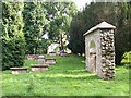
Gate into the Old St Mary's Church site, Woodchester
The gate is locked up but you can climb the steps to the left to get into the site of the old historic church that was superseded by a new church built in the middle of Woodchester, consecrated in September 1863 under the Rector George Henry Evans.
A priest was recorded at Woodchester in 896 and architectural evidence shows that there was a church there in the 12th century. Stone and some memorials were taken to use in the new building.
Image: © Caroline Evans
Taken: 18 Apr 2011
0.12 miles
7
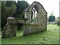
Old St Mary's Church Site, Woodchester
The ancient parish church of St. Mary stood at the northern extremity of the parish and comprised chancel, nave with south aisle and porch, and west tower. On the north side of the church was a raised, covered passage from the church to the edge of the churchyard for occupants of the Priory. The survival of a 12th-century doorway and chancel arch suggests a rebuilding at that date, although most of the external features of the nave and chancel appear to have been late medieval and the tower was probably built in the 15th century. The church contained a monument with effigies to Sir George Huntley and his wife and some wall monuments by Franklin of Stroud and John Ricketts the elder of Gloucester. In 1851 the church was said to have been much modernized, probably in 1815, and 'encumbered with the most hideous pews and galleries'. In 1858 a new Rector George Henry Evans was appointed after eighteen years of service in several parishes in India and a record of getting new churches built. In 1861 it was decided to replace the church and graveyard, which contained a number of carved stone tomb-chests and headstones and remained in use for some further years, with a new building on a site further south. The land was donated by Mrs. Edward Wise and stone from the old church was used in the new building, which comprised chancel, nave with north aisle, south tower with broach spire, and south porch. The new church was consecrated in September 1863. Rev George Henry Evans died in 1878, still Rector.
Image: © Caroline Evans
Taken: 18 Apr 2011
0.12 miles
8
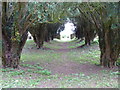
Yew Tree "nave", Old St Mary's Church site, Woodchester
Where the nave would have been looking towards the altar area. Some of the stone and monuments were used for the new Church in Woodchester.
Image: © Caroline Evans
Taken: 18 Apr 2011
0.12 miles
9
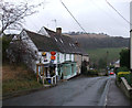
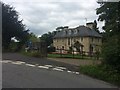
Woodchester Post Office
One of the few village Post Offices that remain open. In the distance is Rodborough Common.
Image: © Vieve Forward
Taken: 30 Dec 2011
0.15 miles
10
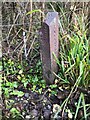
Boundary post, Water Lane
From the days when governance was via Wheatehurst Hundred Division. County above, and parish below. The area is now administered by the Stroud District Council.
Inscription: W H/ D // Kings / Stanley // Woodchester
Milestone Society ID: GL_WOOKST01pb
Image: © Nathan Moore
Taken: 27 Jun 2021
0.17 miles