IMAGES TAKEN NEAR TO
Selsley Common, STROUD, GL5 5PL
Introduction
This page details the photographs taken nearby to Selsley Common, GL5 5PL by members of the Geograph project.
The Geograph project started in 2005 with the aim of publishing, organising and preserving representative images for every square kilometre of Great Britain, Ireland and the Isle of Man.

There are currently over 7.5m images from over14,400 individuals and you can help contribute to the project by visiting https://www.geograph.org.uk
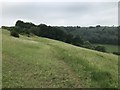
Image Map
Images are licensed for reuse under creativecommons.org/licenses/by-sa/2.0
Notes
- Clicking on the map will re-center to the selected point.
- The higher the marker number, the further away the image location is from the centre of the postcode.
Image Listing (7 Images Found)
Images are licensed for reuse under creativecommons.org/licenses/by-sa/2.0
Image
Details
Distance
1
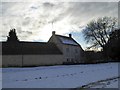
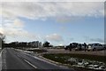
Farm buildings, Boundary Court, Selsey Common
Image: © David Smith
Taken: 29 Dec 2017
0.01 miles
2
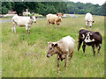
Cows on Selsley Common
With so much land to roam on, these cows have chosen to find pasture perilously close to the B4066. Cattle grids placed a strategic locations prevent the cattle from straying from the commonland.
Image: © Sharon Loxton
Taken: 27 Jun 2006
0.06 miles
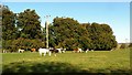
6
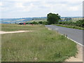
Unfenced road across Selsley Common
Image: © Sarah Charlesworth
Taken: 24 Jun 2010
0.24 miles