IMAGES TAKEN NEAR TO
Selsley Road, STROUD, GL5 5NN
Introduction
This page details the photographs taken nearby to Selsley Road, GL5 5NN by members of the Geograph project.
The Geograph project started in 2005 with the aim of publishing, organising and preserving representative images for every square kilometre of Great Britain, Ireland and the Isle of Man.

There are currently over 7.5m images from over14,400 individuals and you can help contribute to the project by visiting https://www.geograph.org.uk
Image Map
Images are licensed for reuse under creativecommons.org/licenses/by-sa/2.0
Notes
- Clicking on the map will re-center to the selected point.
- The higher the marker number, the further away the image location is from the centre of the postcode.
Image Listing (81 Images Found)
Images are licensed for reuse under creativecommons.org/licenses/by-sa/2.0
Image
Details
Distance
1
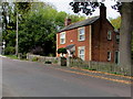
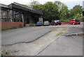
Vine House, North Woodchester
Selsley Road office building near the corner of the A46 Bath Road.
Image: © Jaggery
Taken: 18 Oct 2015
0.00 miles
2
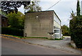
Oak Tree Cottage, North Woodchester
Selsley Road house under an oak tree.
Image: © Jaggery
Taken: 18 Oct 2015
0.01 miles
3
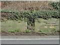
Old Milestone by A46, Rooksmoor
The Milestone is located by the road on the side of the road. Parish of Rodborough (Stroud District). Stone post (plate lost), Nailsworth plate design, erected by the Nailsworth, Woodchester & Dudbridge Turnpike trust in the 19th Century.
Inscription once read:
(Gloucester 12 / Bath 27)
Milestone Society National ID: GL_BAGL27
Image: © Roadside Relics
Taken: 18 Mar 2024
0.02 miles
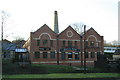
4
Visitor parking area, Woodchester Mill
On the Selsley Road side of this http://www.geograph.org.uk/photo/4723647 converted former mill.
Image: © Jaggery
Taken: 18 Oct 2015
0.02 miles
5
West side of Woodchester Mill
Viewed across Selsley Road in North Woodchester. http://www.geograph.org.uk/photo/4723647 to the Bath Road side of the converted former mill.
Image: © Jaggery
Taken: 18 Oct 2015
0.02 miles
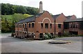
6
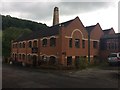
Former Woodchester Mill
Originally textiles, then used by Bentley Pianos and now in multiple occupancy. The electricity substation is still labelled Stroud Piano. The chimney is original but the range closest looks like a total rebuild.
Image: © Chris Allen
Taken: 17 Jan 2010
0.02 miles
7
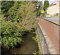
Nailsworth Stream, North Woodchester
Flowing below the A46 Bath Road, viewed from the corner of Selsley Road.
Image: © Jaggery
Taken: 18 Oct 2015
0.02 miles
8
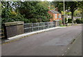
Selsley Road bridge, North Woodchester
There is a 17 tonnes weight limit on this bridge carrying Selsley Road
over a dismantled railway trackbed, now a footpath and cycle route. http://www.geograph.org.uk/photo/4723669
Oak Tree Cottage http://www.geograph.org.uk/photo/4723202 is on the right.
Image: © Jaggery
Taken: 18 Oct 2015
0.03 miles
9
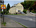
Warning sign - traffic lights ahead, Bath Road, Rooksmoor
In the UK, warning road signs are triangular and red-edged.
Image: © Jaggery
Taken: 18 Oct 2015
0.03 miles