IMAGES TAKEN NEAR TO
Stanley End, STROUD, GL5 5JX
Introduction
This page details the photographs taken nearby to Stanley End, GL5 5JX by members of the Geograph project.
The Geograph project started in 2005 with the aim of publishing, organising and preserving representative images for every square kilometre of Great Britain, Ireland and the Isle of Man.

There are currently over 7.5m images from over14,400 individuals and you can help contribute to the project by visiting https://www.geograph.org.uk
Image Map (Loading...)


Getting Data...Please wait
Leaflet Map data © OpenStreetMap
Images are licensed for reuse under creativecommons.org/licenses/by-sa/2.0
Notes
- Clicking on the map will re-center to the selected point.
- The higher the marker number, the further away the image location is from the centre of the postcode.
Image Listing (19 Images Found)
Images are licensed for reuse under creativecommons.org/licenses/by-sa/2.0
Image
Details
Distance
1
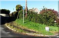
Street furniture, Selsley, Gloucestershire
Image: © nick macneill
Taken: 14 Oct 2012
0.02 miles
2
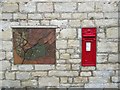
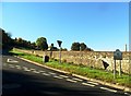
Map and Postbox - Selsley
On the end wall of The Bell on the main road is a map of Selsley and its surrounding area together with the postbox.
Image: © Sarah Smith
Taken: 4 Nov 2015
0.03 miles
3
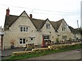
The Bell, Selsley
This old Inn is 16C and Grade II listed; it has an extensive view overlooking the rooftops of Stroud to Rodborough Common beyond.
Image: © Sarah Smith
Taken: 4 Nov 2015
0.03 miles
4
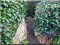
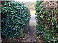
Stone Stile, Selsley
Near the Bell Inn, on the SE side of the road. This is the view SE, the view looking out is Image
Image: © Mr Red
Taken: 10 Dec 2021
0.08 miles
5
Stone Stile, Selsley
Near the Bell Inn, on the SE side of the road. This is the view NW, the view looking SE Image
Image: © Mr Red
Taken: 10 Dec 2021
0.08 miles
6
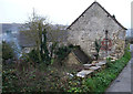
Farmhouse near Selsley
Looking rather ramshackle beside the lane leading south out of Selsley, this farmhouse is still clearly a working establishment.
Image: © Vieve Forward
Taken: 30 Dec 2011
0.08 miles
8
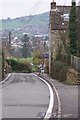
Selsley
The B4066 road rises through Selsley a bit too steeply for this cyclist. Randwick rises across the other side of the valley.
Image: © Peter Kwan
Taken: 31 Dec 2002
0.09 miles
9

The Cotswold Way below Selsley
Stroud is in the valley below, but the Cotswold Way runs a bit to the left nearer to Ebley.
Image: © Bill Boaden
Taken: 17 Jul 2016
0.10 miles
10
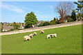
Sheep Grazing
Sheep off New Road, Selsey.
Image: © Wayland Smith
Taken: 6 May 2013
0.10 miles