IMAGES TAKEN NEAR TO
Inchbrook, STROUD, GL5 5HL
Introduction
This page details the photographs taken nearby to GL5 5HL by members of the Geograph project.
The Geograph project started in 2005 with the aim of publishing, organising and preserving representative images for every square kilometre of Great Britain, Ireland and the Isle of Man.

There are currently over 7.5m images from over14,400 individuals and you can help contribute to the project by visiting https://www.geograph.org.uk
Image Map
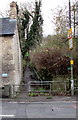
Images are licensed for reuse under creativecommons.org/licenses/by-sa/2.0
Notes
- Clicking on the map will re-center to the selected point.
- The higher the marker number, the further away the image location is from the centre of the postcode.
Image Listing (44 Images Found)
Images are licensed for reuse under creativecommons.org/licenses/by-sa/2.0
Image
Details
Distance
1
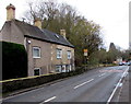
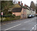
Stroud Road houses, Nailsworth
On the west side of the A46 Stroud Road.
Image: © Jaggery
Taken: 20 Dec 2015
0.00 miles
2
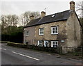
Haysdene, Nailsworth
Viewed across the A46 Stroud Road in the north of Nailsworth.
Image: © Jaggery
Taken: 20 Dec 2015
0.01 miles
3
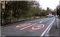
Queues likely at peak times, Stroud Road, Nailsworth
The sign faces northbound traffic on the A46 Stroud Road.
Image: © Jaggery
Taken: 20 Dec 2015
0.01 miles
5
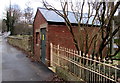
Stroud Road electricity substation, Nailsworth
The Western Power Distribution electricity substation is inside a brick building alongside the A46 Stroud Road.
A bus stop sign is on a pole at the edge of the substation.
Image: © Jaggery
Taken: 20 Dec 2015
0.02 miles
6
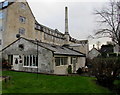
Old Counting House, Dunkirk Mills, Nailsworth
The name on the single-storey building is The Old Counting House,
part of the former Dunkirk Mills, converted to residential use.
Image: © Jaggery
Taken: 20 Dec 2015
0.03 miles
7
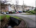
Entrance road to Dunkirk Mills, Nailsworth
From the east side of the A46 Stroud Road, the road crosses a bridge over Nailsworth Stream.
The former textile mills have been converted to residential use.
Image: © Jaggery
Taken: 20 Dec 2015
0.03 miles
8
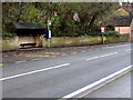
Dunkirk Mills bus stop and shelter, Stroud Road, Nailsworth
Viewed across the A46 Stroud Road. This stop is for buses towards Stroud.
Image: © Jaggery
Taken: 20 Dec 2015
0.03 miles
9
Path from Nailsworth towards Inchbrook Hill
Ascending from the west side of the A46 Stroud Road.
Image: © Jaggery
Taken: 20 Dec 2015
0.03 miles
10
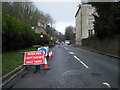
Check your speed, Stroud Road, Nailsworth
The notice on a pole on the left reminds drivers that the speed limit on this part of the A46 is 40mph.
Image: © Jaggery
Taken: 20 Dec 2015
0.04 miles