IMAGES TAKEN NEAR TO
Houndscroft, STROUD, GL5 5DG
Introduction
This page details the photographs taken nearby to Houndscroft, GL5 5DG by members of the Geograph project.
The Geograph project started in 2005 with the aim of publishing, organising and preserving representative images for every square kilometre of Great Britain, Ireland and the Isle of Man.

There are currently over 7.5m images from over14,400 individuals and you can help contribute to the project by visiting https://www.geograph.org.uk
Image Map
Images are licensed for reuse under creativecommons.org/licenses/by-sa/2.0
Notes
- Clicking on the map will re-center to the selected point.
- The higher the marker number, the further away the image location is from the centre of the postcode.
Image Listing (44 Images Found)
Images are licensed for reuse under creativecommons.org/licenses/by-sa/2.0
Image
Details
Distance
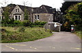
1
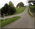
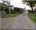
Junction at the edge of Littleworth Common, Gloucestershire
Turn left for Littleworth Common, Lower Littleworth and St Chloe.
Image: © Jaggery
Taken: 18 Oct 2015
0.03 miles
2
Solar panels on a bungalow near Littleworth Common, Gloucestershire
Image: © Jaggery
Taken: 18 Oct 2015
0.04 miles
3
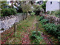
Wooden posts on a track near Littleworth Common, Gloucestershire
Between Littleworth Common and Minchinhampton Common.
Image: © Jaggery
Taken: 18 Oct 2015
0.04 miles
4
Track towards Littleworth Common, Gloucestershire
A faint track on the right heads south away from Amberley Ridge http://www.geograph.org.uk/photo/4738878 near Minchinhampton Common.
Image: © Jaggery
Taken: 18 Oct 2015
0.05 miles
5
Road towards a cattle grid near Littleworth Common, Gloucestershire
The grid is across the road near the tree.
Image: © Jaggery
Taken: 18 Oct 2015
0.05 miles
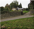
6
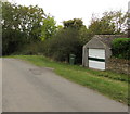
Lockup garage alongside the road through Littleworth Common, Gloucestershire
Near Lower Littleworth.
Image: © Jaggery
Taken: 18 Oct 2015
0.06 miles
7
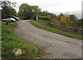
Road to Lower Littleworth, Gloucestershire
Through Littleworth Common.
Image: © Jaggery
Taken: 18 Oct 2015
0.07 miles
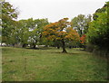
8
House at the edge of Minchinhampton Common
Minchinhampton Common is common land in the Gloucestershire Cotswolds south of Stroud.
Image: © Jaggery
Taken: 18 Oct 2015
0.12 miles
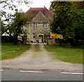
9
Entrance to Amberley Ridge, Houndscroft
Located at the edge of Minchinhampton Common, Amberley Ridge is a former special needs school viewed in October 2015. A Gloucestershire County Council notice at the entrance shows
NO UNAUTHORISED USE OF PLAYING FIELD
EXERCISING OF DOGS STRICTLY FORBIDDEN.
Image: © Jaggery
Taken: 18 Oct 2015
0.12 miles
10
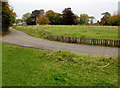
Side road past Amberley Ridge, Houndscroft
The former school Amberley Ridge http://www.geograph.org.uk/photo/4738878 is a few metres out of shot on the left.
Image: © Jaggery
Taken: 18 Oct 2015
0.12 miles