IMAGES TAKEN NEAR TO
Rodborough Common, STROUD, GL5 5DA
Introduction
This page details the photographs taken nearby to GL5 5DA by members of the Geograph project.
The Geograph project started in 2005 with the aim of publishing, organising and preserving representative images for every square kilometre of Great Britain, Ireland and the Isle of Man.

There are currently over 7.5m images from over14,400 individuals and you can help contribute to the project by visiting https://www.geograph.org.uk
Image Map (Loading...)


Getting Data...Please wait
Leaflet Map data © OpenStreetMap
Images are licensed for reuse under creativecommons.org/licenses/by-sa/2.0
Notes
- Clicking on the map will re-center to the selected point.
- The higher the marker number, the further away the image location is from the centre of the postcode.
Image Listing (45 Images Found)
Images are licensed for reuse under creativecommons.org/licenses/by-sa/2.0
Image
Details
Distance
1
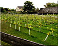
Hanna's Vineyard, Rodborough Common
In Gloucestershire south of the Bear of Rodborough Hotel. http://www.geograph.org.uk/photo/4705283
Image: © Jaggery
Taken: 18 Oct 2015
0.03 miles
2
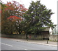
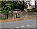
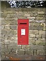
Autumn colours, Rodborough Common
Viewed on October 18th 2015.
The red postbox http://www.geograph.org.uk/photo/4705306 in the wall is from the reign of King George VI (1936-1952).
Image: © Jaggery
Taken: 18 Oct 2015
0.03 miles
3
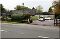
Hotel side building, Rodborough Common
Part of the Bear of Rodborough hotel http://www.geograph.org.uk/photo/4705283 site, this building includes a restaurant & bar and conference rooms.
Image: © Jaggery
Taken: 18 Oct 2015
0.05 miles
4
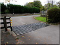
Cattle grid on Rodborough Common
A nearby notice states that five hundred cattle roam freely on Rodborough Common.
Image: © Jaggery
Taken: 18 Oct 2015
0.05 miles
5
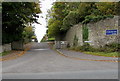
Bownham Mead, Rodborough Common
The small street name sign on the wall shows BOWNHAM MEAD.
The dark blue sign shows Bownham Park Centre.
This location is in the Gloucestershire Cotswolds south of Stroud.
Image: © Jaggery
Taken: 18 Oct 2015
0.05 miles
6
Bownham School electricity substation, Bownham
The Western Power Distribution electricity substation identifier is
10782 BOWNHAM SCHOOL.
This location is in the Gloucestershire Cotswolds south of Stroud.
Image: © Jaggery
Taken: 18 Oct 2015
0.05 miles
7
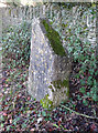
Old Boundary Marker
Parish Boundary Marker on the west side of Cirencester Road. On the boundary of Minchinhampton and Rodborough parishes. Inscribed HERE / FIND ..... / PARK ..... (might be PARK LANE) / RO_ _ _ NICII on its centre face.
Milestone Society National ID: GL_MINROD02pb
Image: © Mr Red
Taken: 22 Dec 2018
0.07 miles
9
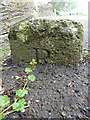
Old Boundary Marker
Parish Boundary Marker on the pavement on the east side of Cirencester Road at the foot of a pillar for Shepherds Well housing estate. On the boundary of Minchinhampton and Rodborough parishes. Inscribed M and R on opposite faces.
Milestone Society National ID: GL_MINROD01pb
Image: © Mr Red
Taken: 16 Apr 2019
0.07 miles
10
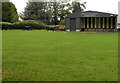
Croquet pavilion and picnic benches, Rodborough Common
In the grounds of the Bear of Rodborough Hotel. http://www.geograph.org.uk/photo/4705283
Image: © Jaggery
Taken: 18 Oct 2015
0.07 miles