IMAGES TAKEN NEAR TO
Parsons Lane, CHIPPING CAMPDEN, GL55 6QR
Introduction
This page details the photographs taken nearby to Parsons Lane, GL55 6QR by members of the Geograph project.
The Geograph project started in 2005 with the aim of publishing, organising and preserving representative images for every square kilometre of Great Britain, Ireland and the Isle of Man.

There are currently over 7.5m images from over14,400 individuals and you can help contribute to the project by visiting https://www.geograph.org.uk
Image Map (42 Images)


Getting Data...Please wait
Leaflet Map data © OpenStreetMap
Images are licensed for reuse under creativecommons.org/licenses/by-sa/2.0
Notes
- Clicking on the map will re-center to the selected point.
- The higher the marker number, the further away the image location is from the centre of the postcode.
Image Listing (42 Images Found)
Images are licensed for reuse under creativecommons.org/licenses/by-sa/2.0
Image
Details
Distance
1
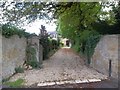
Stables driveway
The driveway leads to The Old Stables, formerly the stable block for The Rectory.
Image: © Michael Dibb
Taken: 22 Aug 2010
0.03 miles
2
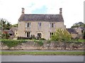
Manor Farmhouse
The farmhouse has a datestone of 1624 and offers bed and breakfast accommodation.
Image: © Michael Dibb
Taken: 22 Aug 2010
0.05 miles
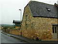
3
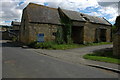
Barn at Weston-sub-Edge
A Cotswold stone built barn in a bit of a sad state awaiting sale and conversion.
Image: © Philip Halling
Taken: 19 Jul 2008
0.06 miles
4
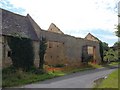
Derelict Barn
The barn is part of Manor Farm and has completely lost its roof in recent years.
Image: © Michael Dibb
Taken: 22 Aug 2010
0.06 miles
5
Manor Barn, Weston-Sub-Edge
The converted listed barn is described at https://historicengland.org.uk/listing/the-list/list-entry/1387229?section=official-list-entry .
Image: © Derek Harper
Taken: 14 Sep 2021
0.07 miles

7
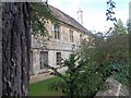
Manor House
The Manor House in Weston-sub-Edge is well hidden behind its walls.
Image: © Michael Dibb
Taken: 22 Aug 2010
0.09 miles
8
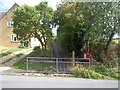
Start of footpath
The footpath to Aston Subedge leaves the minor road in Weston-sub-Edge. Note the different spellings of the two villages.
Image: © Michael Dibb
Taken: 22 Aug 2010
0.09 miles
9
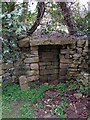
Restored water supply,non-functional
Weston Subedge relied on water from this type of installation.Ground water from nearby Dover's Hill.
Image: © Liz Stone
Taken: 29 Mar 2011
0.10 miles
10

White cattle grazing
Looking NNE from Dover's View.
The old ridge and furrow contours of the field are clearly visible.
Image: © David P Howard
Taken: 12 Aug 2016
0.10 miles