IMAGES TAKEN NEAR TO
Mickleton, CHIPPING CAMPDEN, GL55 6PS
Introduction
This page details the photographs taken nearby to GL55 6PS by members of the Geograph project.
The Geograph project started in 2005 with the aim of publishing, organising and preserving representative images for every square kilometre of Great Britain, Ireland and the Isle of Man.

There are currently over 7.5m images from over14,400 individuals and you can help contribute to the project by visiting https://www.geograph.org.uk
Image Map
Images are licensed for reuse under creativecommons.org/licenses/by-sa/2.0
Notes
- Clicking on the map will re-center to the selected point.
- The higher the marker number, the further away the image location is from the centre of the postcode.
Image Listing (7 Images Found)
Images are licensed for reuse under creativecommons.org/licenses/by-sa/2.0
Image
Details
Distance
1
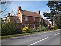
Nineveh Farmhouse
Seen from the B4081 road. The farm offers bed and breakfast accommodation.
Image: © Michael Dibb
Taken: 10 Apr 2011
0.04 miles
2
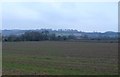
Countryside near Mickleton
Taken at 4.30pm on a cloudy winter day, resulted in poor light conditions. This is the view towards Ninevah Farm from the B4632 Mickleton to Broadway road.
Image: © Nigel Mykura
Taken: 20 Feb 2011
0.08 miles
3
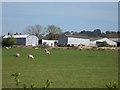
Long Hills Farm
Seen, across the fields, from the B4081 road.
Image: © Michael Dibb
Taken: 10 Apr 2011
0.16 miles
4
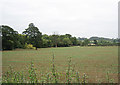
Fields near Mickleton
Looking west towards the Cotswolds from the Broadway to Mickleton road.
Image: © Dave Bushell
Taken: 3 Oct 2005
0.19 miles
5
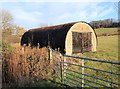
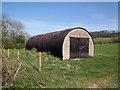
Tubular shed near Nineveh Farm
This unusual shed is to the east of the B4081 Campden Road, near Nineveh Farm. The gate is a recent addition. Compare with Image
Image: © David P Howard
Taken: 17 Dec 2011
0.20 miles
7
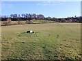
Fields west of Baker's Hill
Looking ESE across the fields towards Baker's Hill in Image
Image: © David P Howard
Taken: 17 Dec 2011
0.21 miles