IMAGES TAKEN NEAR TO
Charingworth, CHIPPING CAMPDEN, GL55 6NU
Introduction
This page details the photographs taken nearby to GL55 6NU by members of the Geograph project.
The Geograph project started in 2005 with the aim of publishing, organising and preserving representative images for every square kilometre of Great Britain, Ireland and the Isle of Man.

There are currently over 7.5m images from over14,400 individuals and you can help contribute to the project by visiting https://www.geograph.org.uk
Image Map
Images are licensed for reuse under creativecommons.org/licenses/by-sa/2.0
Notes
- Clicking on the map will re-center to the selected point.
- The higher the marker number, the further away the image location is from the centre of the postcode.
Image Listing (12 Images Found)
Images are licensed for reuse under creativecommons.org/licenses/by-sa/2.0
Image
Details
Distance
1
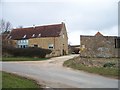
Charingworth conversions
This large farm estate complex has all been converted to residential accommodation. Seen from the minor road to the B4035. The signpost shows the start of the footpath.
Image: © Michael Dibb
Taken: 6 Mar 2010
0.01 miles
2
![Charingworth conversions [1]](https://s1.geograph.org.uk/geophotos/01/79/31/1793141_338e7e14_120x120.jpg)
Charingworth conversions [1]
This large farm estate complex has all been converted to residential accommodation. Seen from the footpath.
Image: © Michael Dibb
Taken: 6 Mar 2010
0.01 miles
3
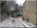
Steep bank
This minor road runs to Ilmington. Here, as it leaves Charingworth past Magpie Cottage, it is both narrow and steep.
Image: © Michael Dibb
Taken: 6 Mar 2010
0.11 miles
4
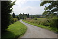
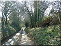
Lane to Goose Hill
From the hamlet of Charingworth.
Image: © Trevor Harris
Taken: 23 Jul 2014
0.11 miles
5
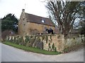
Garden wall
This garden wall always looks magnificent in summer - usually without the dog.
Image: © Michael Dibb
Taken: 6 Mar 2010
0.11 miles
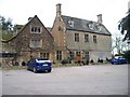
8
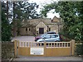
Charingworth Manor
Seen from the minor road to Ebrington, the manor is now a hotel.
Image: © Michael Dibb
Taken: 6 Mar 2010
0.19 miles
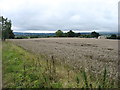
9
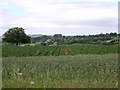
Wheat, potatoes & Ebrington
View west from Goose Hill over a field that had wheat around the edges and potatoes in the middle, towards the village of Ebrington in the distance.
Image: © David P Howard
Taken: 4 Jul 2010
0.19 miles
10
Charingworth Manor
Seen from the minor road to Ebrington, the manor is now a hotel.
Image: © Michael Dibb
Taken: 6 Mar 2010
0.20 miles