IMAGES TAKEN NEAR TO
Cider Mill Lane, CHIPPING CAMPDEN, GL55 6HT
Introduction
This page details the photographs taken nearby to Cider Mill Lane, GL55 6HT by members of the Geograph project.
The Geograph project started in 2005 with the aim of publishing, organising and preserving representative images for every square kilometre of Great Britain, Ireland and the Isle of Man.

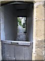
There are currently over 7.5m images from over14,400 individuals and you can help contribute to the project by visiting https://www.geograph.org.uk
Image Map
Images are licensed for reuse under creativecommons.org/licenses/by-sa/2.0
Notes
- Clicking on the map will re-center to the selected point.
- The higher the marker number, the further away the image location is from the centre of the postcode.
Image Listing (199 Images Found)
Images are licensed for reuse under creativecommons.org/licenses/by-sa/2.0
Image
Details
Distance
1
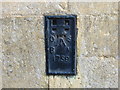
Ordnance Survey Flush Bracket 1759
This bracket can be found on the roadside wall of a building in High Street, Chipping Campden. The benchmark height is recorded as being 144.026 metres above sea level. For more detail see : http://www.bench-marks.org.uk/bm10272
Image: © Peter Wood
Taken: 6 Nov 2017
0.01 miles
2
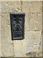
Ordnance Survey Flush Bracket (1759)
This OS Flush Bracket can be found on the west face of The Corner House. It marks a point 144.0220m above mean sea level.
Image: © Adrian Dust
Taken: 27 Jun 2015
0.02 miles
4
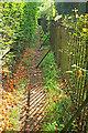
Approaching Chipping Campden
On Chipping Campden footpath 7#1, here carrying three LDPs: the Monarch's Way, the Heart of England Way and the Diamond Way. In view of this, the capacity looks a little limited, though we met no-one on this stretch.
Image: © Derek Harper
Taken: 15 Sep 2021
0.03 miles
5
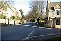
Chipping Campden
Passage to the back of houses on the main street in Chipping.
Image: © Janet Lute
Taken: 29 Dec 2004
0.04 miles
6
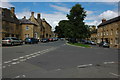
Chipping Campden
Picturesque Cotswold town popular with visitors.
Image: © Philip Halling
Taken: 19 Jul 2008
0.05 miles
7
Church Street, Chipping Campden
Looking left from Image On the right is part of the listed churchyard walls https://historicengland.org.uk/listing/the-list/list-entry/1305478 .
Image: © Derek Harper
Taken: 15 Sep 2021
0.06 miles
8
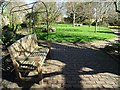
Ernest Wilson Memorial Garden
Ernest Wilson was born in Chipping Campden in 1876, he was an explorer and plant collector. He was killed with his wife in an automobile accident in Worcester, Massachusetts on 15 October 1930.
Image: © Philip Halling
Taken: 24 Mar 2019
0.06 miles
9

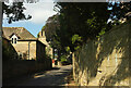
Chipping Campden-Leysbourne
Stone Cottages on the Leysbourne.
Image: © Ian Rob
Taken: 22 Aug 2010
0.07 miles
10
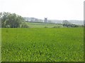
Church tower
Seen from the minor road, the church tower is seemingly isolated in the middle of fields. It is, however, the tower of the church of St James in Chipping Campden, almost a mile away.
Image: © Michael Dibb
Taken: 10 Apr 2011
0.07 miles