IMAGES TAKEN NEAR TO
Back Ends, CHIPPING CAMPDEN, GL55 6AB
Introduction
This page details the photographs taken nearby to Back Ends, GL55 6AB by members of the Geograph project.
The Geograph project started in 2005 with the aim of publishing, organising and preserving representative images for every square kilometre of Great Britain, Ireland and the Isle of Man.

There are currently over 7.5m images from over14,400 individuals and you can help contribute to the project by visiting https://www.geograph.org.uk
Image Map
Images are licensed for reuse under creativecommons.org/licenses/by-sa/2.0
Notes
- Clicking on the map will re-center to the selected point.
- The higher the marker number, the further away the image location is from the centre of the postcode.
Image Listing (262 Images Found)
Images are licensed for reuse under creativecommons.org/licenses/by-sa/2.0
Image
Details
Distance
1

Chipping Campden-Leysbourne
Stone Cottages on the Leysbourne.
Image: © Ian Rob
Taken: 22 Aug 2010
0.04 miles
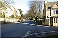
2
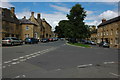
Chipping Campden
Passage to the back of houses on the main street in Chipping.
Image: © Janet Lute
Taken: 29 Dec 2004
0.04 miles
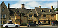
3
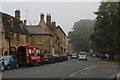
Chipping Campden
Picturesque Cotswold town popular with visitors.
Image: © Philip Halling
Taken: 19 Jul 2008
0.05 miles
5
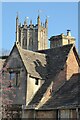
Cotswold roofs
View to the tower of St James church with the gables of a Cotswold cottage in the foreground.
Image: © Philip Halling
Taken: 25 Nov 2021
0.06 miles
6
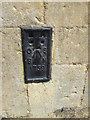
Ordnance Survey Flush Bracket (1759)
This OS Flush Bracket can be found on the west face of The Corner House. It marks a point 144.0220m above mean sea level.
Image: © Adrian Dust
Taken: 27 Jun 2015
0.06 miles
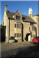
7
Holmoak, Chipping Campden
At the junction of the High Street with Church Street. https://historicengland.org.uk/listing/the-list/list-entry/1342003?section=official-list-entry
Image: © Derek Harper
Taken: 15 Sep 2021
0.06 miles
9
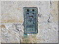
Ordnance Survey Flush Bracket 1760
This bracket can be found on the roadside wall of a building in High Street, Chipping Campden. The benchmark height is recorded as being 141.613 metres above sea level. For more detail see : http://www.bench-marks.org.uk/bm10273
Image: © Peter Wood
Taken: 6 Nov 2017
0.06 miles
10
Miles House
Miles House was two 17th century cottages, which was converted into a single house is the 19th century. It was further remodelled by the Arts and Crafts F.L. Griggs in 1917.
Image: © Philip Halling
Taken: 25 Nov 2021
0.07 miles