IMAGES TAKEN NEAR TO
Townsend, STROUD, GL5 4RY
Introduction
This page details the photographs taken nearby to Townsend, GL5 4RY by members of the Geograph project.
The Geograph project started in 2005 with the aim of publishing, organising and preserving representative images for every square kilometre of Great Britain, Ireland and the Isle of Man.

There are currently over 7.5m images from over14,400 individuals and you can help contribute to the project by visiting https://www.geograph.org.uk
Image Map (Loading...)


Getting Data...Please wait
Leaflet Map data © OpenStreetMap
Images are licensed for reuse under creativecommons.org/licenses/by-sa/2.0
Notes
- Clicking on the map will re-center to the selected point.
- The higher the marker number, the further away the image location is from the centre of the postcode.
Image Listing (33 Images Found)
Images are licensed for reuse under creativecommons.org/licenses/by-sa/2.0
Image
Details
Distance
1
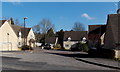
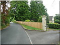
More Hall Park, Randwick near Stroud
A small cul-de-sac on the east side of Cashes Green Road.
Image: © Jaggery
Taken: 17 Feb 2013
0.05 miles
2
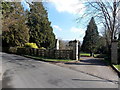
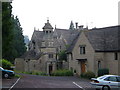
Entrance to More Hall Convent residential care home, Randwick
Located in Randwick near Stroud.
Image: © Jaggery
Taken: 17 Feb 2013
0.05 miles
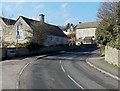
3
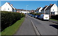
The Wordens, Stroud
A 125-metre long cul-de-sac viewed from the Foxmoor Lane end
looking towards the turning circle at the far end of The Wordens.
Image: © Jaggery
Taken: 17 Feb 2013
0.05 miles
4
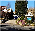
Townsend name sign, Randwick
Townsend is part of the village of Randwick to the north of Stroud.
Image: © Jaggery
Taken: 17 Feb 2013
0.05 miles
5
The lane through Randwick at the More Hall Convent Care Home
Image: © Humphrey Bolton
Taken: 11 Jul 2017
0.05 miles
6
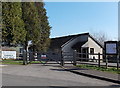
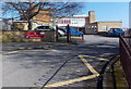
Randwick Scout Group hall
Viewed across Cashes Green Road in Randwick, a village at the northern edge of Stroud.
Image: © Jaggery
Taken: 17 Feb 2013
0.06 miles
7
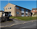
Henley Court flats, Stroud
Viewed across Cashes Green Road. The 4 flats are opposite Cashes Green Primary School. http://www.geograph.org.uk/photo/3814398
Image: © Jaggery
Taken: 17 Feb 2013
0.07 miles
8
Blenheim House and Blenheim Cottage, Townsend, Randwick
Looking past Blenheim House, parallel with the road, towards Blenheim Cottage.
Image: © Jaggery
Taken: 17 Feb 2013
0.07 miles
9
Chapel, More Hall Convent
The chapel, with its octagonal belfry was converted from a dovecote in the early C20. The house beside it dates from the late C16 and early C17. The convent is run as a care home by the Grace and Compassion Benedictines, an order started in the 1950s.
Image: © Derek Harper
Taken: 5 Jul 2006
0.08 miles
10
Entrance to Cashes Green Primary School, Stroud
Opened in 1957, Cashes Green Primary School is located halfway up Randwick Hill.
There are 6 mixed-ability classes, for a total of about 150 children.
Image: © Jaggery
Taken: 17 Feb 2013
0.09 miles