IMAGES TAKEN NEAR TO
Cashes Green Road, STROUD, GL5 4RA
Introduction
This page details the photographs taken nearby to Cashes Green Road, GL5 4RA by members of the Geograph project.
The Geograph project started in 2005 with the aim of publishing, organising and preserving representative images for every square kilometre of Great Britain, Ireland and the Isle of Man.

There are currently over 7.5m images from over14,400 individuals and you can help contribute to the project by visiting https://www.geograph.org.uk
Image Map
Images are licensed for reuse under creativecommons.org/licenses/by-sa/2.0
Notes
- Clicking on the map will re-center to the selected point.
- The higher the marker number, the further away the image location is from the centre of the postcode.
Image Listing (23 Images Found)
Images are licensed for reuse under creativecommons.org/licenses/by-sa/2.0
Image
Details
Distance
1
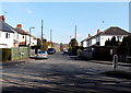
Kingley Road, Stroud
Viewed from Cashes Green Road.
Image: © Jaggery
Taken: 17 Feb 2013
0.06 miles
2
Spinning Wheel Court, Stroud
A small cul-de-sac on the east side of Cashes Green Road.
Image: © Jaggery
Taken: 17 Feb 2013
0.06 miles
3
Hunters Way, Stroud
Viewed from the Cashes Green Road end.
Image: © Jaggery
Taken: 17 Feb 2013
0.07 miles
4
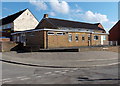
Cashes Green Community Centre, Stroud
On the corner of Cashes Green Road and Queens Drive.
Cashes Green Stores http://www.geograph.org.uk/photo/3821267 are on the left, in Queens Drive.
Image: © Jaggery
Taken: 17 Feb 2013
0.08 miles
5
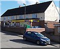
Cashes Green Stores, Stroud
Premier store in Queens Drive, viewed from the corner of Cashes Green Road.
Image: © Jaggery
Taken: 17 Feb 2013
0.09 miles
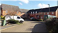
6
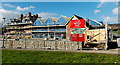
Applewood under construction, Stroud
Viewed in February 2013. Houses are being built on the site of the demolished Cashes Green Hospital.
Image: © Jaggery
Taken: 17 Feb 2013
0.09 miles
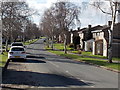
7
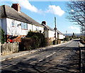
Cashes Green Road houses, Stroud
Between Kingley Road behind the camera and Hyett Road ahead.
Image: © Jaggery
Taken: 17 Feb 2013
0.10 miles
8
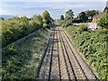
Cashes Green railway Halt (site), Gloucestershire
Opened in 1930 by the Great Western Railway on the line from Swindon to Gloucester, this station closed in 1964.
View west towards Ebley Crossing and Gloucester. No trace appears to remain of the two short parallel platforms here.
Image: © Nigel Thompson
Taken: 9 Oct 2021
0.13 miles
9
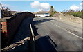
Cashes Green Road railway bridge, Stroud
The bridge, identifier 103 21 SWM, carries the road over railway lines c2km west of Stroud railway station.
Image: © Jaggery
Taken: 17 Feb 2013
0.13 miles
10
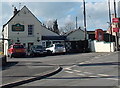
Prince of Wales, Cashes Green, Stroud
Pub near the corner of Cashes Green Road and Springfield Road.
Image: © Jaggery
Taken: 17 Feb 2013
0.14 miles