1
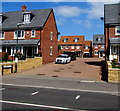
John Harper Close, Stroud
Recently built cul-de-sac on the north side of the A419 Cainscross Road viewed in May 2017.
Image: © Jaggery
Taken: 7 May 2017
0.01 miles
2
Carpet & Flooring shop in Stroud
Viewed across Cainscross Road.
Image: © Jaggery
Taken: 17 Feb 2013
0.03 miles
3
Double-decker bus, Cainscross Road, Stroud
Text on the side of the bus is "abus 1991-2016 Serving Bristol for over 25 years".
Abus is an independent bus company providing local bus services in Bristol, Bath and surrounding areas. Stroud doesn't quite match that area, and the electronic display on the front of the bus shows only the company's website address, from which I concluded that this bus is on special hire, not on a regular route.
Image: © Jaggery
Taken: 7 May 2017
0.04 miles
4
Three bus bays near Stroud High School, Stroud
The bays numbered 15,14,13 on Cainscross Road are used by school buses.
Image: © Jaggery
Taken: 7 May 2017
0.05 miles
5
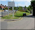
Lodgemore Lane, Stroud
Lodgemore Lane descends from Cainscross Road towards the Stroudwater Canal.
The WSP Textiles notice shows CAUTION - NARROW ROAD - NO CONTAINERS, NO TURNING.
Image: © Jaggery
Taken: 7 May 2017
0.05 miles
6
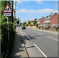
Warning sign - School, Cainscross Road, Stroud
Facing westbound traffic on the A419 Cainscross Road on the approach to Stroud High School.
Image: © Jaggery
Taken: 7 May 2017
0.05 miles
7
Beard's Lane, Stroud
Beard's Lane ascends from the north side of the A419 Cainscross Road.
Image: © Jaggery
Taken: 7 May 2017
0.07 miles
8
Cainscross Road houses, Stroud
Viewed looking towards the Beard's Lane junction.
Image: © Jaggery
Taken: 17 Feb 2013
0.08 miles
9
Queen Elizabeth II postbox on a Stroud corner
On the corner of the A419 Cainscross Road and Beard's Lane.
Image: © Jaggery
Taken: 7 May 2017
0.08 miles
10
Beard's Lane, Stroud
Viewed from Cainscross Road. This is not a through route for vehicles.
Walkers can reach Stratford Road via a railway level crossing.
Image: © Jaggery
Taken: 17 Feb 2013
0.08 miles


