IMAGES TAKEN NEAR TO
Orchard Road, CHELTENHAM, GL54 5QB
Introduction
This page details the photographs taken nearby to Orchard Road, GL54 5QB by members of the Geograph project.
The Geograph project started in 2005 with the aim of publishing, organising and preserving representative images for every square kilometre of Great Britain, Ireland and the Isle of Man.

There are currently over 7.5m images from over14,400 individuals and you can help contribute to the project by visiting https://www.geograph.org.uk
Image Map
Images are licensed for reuse under creativecommons.org/licenses/by-sa/2.0
Notes
- Clicking on the map will re-center to the selected point.
- The higher the marker number, the further away the image location is from the centre of the postcode.
Image Listing (92 Images Found)
Images are licensed for reuse under creativecommons.org/licenses/by-sa/2.0
Image
Details
Distance
1
![The view from the hill [2]](https://s2.geograph.org.uk/geophotos/02/52/50/2525046_64f5d23a_120x120.jpg)
The view from the hill [2]
This view from the lane shows Winchcombe at the bottom of the hill with Salters Hill behind. The light roof just right of centre is part of Enfield Farm.
Image: © Michael Dibb
Taken: 10 Jul 2011
0.02 miles
2

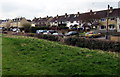
Fields behind the houses on Orchard Road, Winchcombe
Image: © Liz Stone
Taken: 30 Jul 2012
0.08 miles
3
Back Lane houses opposite an open space, Winchcombe
Viewed from a grassy area north of St Peter's churchyard.
Image: © Jaggery
Taken: 5 Apr 2015
0.15 miles
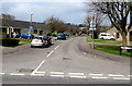
4
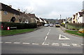
Barnmeadow Road, Winchcombe
From Back Lane looking towards Orchard Road.
Image: © Jaggery
Taken: 5 Apr 2015
0.15 miles
5
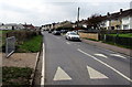
Back Lane houses, Winchcombe
Viewed over speed bumps.
Image: © Jaggery
Taken: 5 Apr 2015
0.16 miles
6
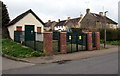
Electricity substation, Back Lane, Winchcombe
One of the Danger Keep Out notices on the locked gates shows Western Power Distribution.
The other one shows Midlands Electricity plc.
Image: © Jaggery
Taken: 5 Apr 2015
0.16 miles
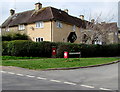
7
Cipherless postbox on a Winchcombe corner
Most UK postboxes have a royal cipher to indicate the reign in which they were made.
This exception is on the corner http://www.geograph.org.uk/photo/4421427 of Barnmeadow Road and Back Lane, Winchcombe.
Richard Ellis has informed me that the crown shows that it is a King George V box.
Image: © Jaggery
Taken: 5 Apr 2015
0.17 miles
8
Summers Road, Winchcombe
Bungalows on the north side of Back Lane.
Image: © Jaggery
Taken: 5 Apr 2015
0.18 miles
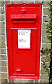
9
Unusual postbox on a Winchcombe corner
The postbox http://www.geograph.org.uk/photo/4421426 on the corner of Barnmeadow Road and Back Lane is unusual in not having
a royal cipher to indicate the reign in which it was made. The style of the box suggests Victorian.
Image: © Jaggery
Taken: 5 Apr 2015
0.19 miles
10
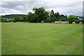
Abbey Fields, Winchcombe
Not very much is left of the abbey. Ahead is St Peter's Church and you can also see some signals in the railway museum.
Image: © Bill Boaden
Taken: 20 Jul 2015
0.19 miles