IMAGES TAKEN NEAR TO
Hailes, CHELTENHAM, GL54 5PB
Introduction
This page details the photographs taken nearby to GL54 5PB by members of the Geograph project.
The Geograph project started in 2005 with the aim of publishing, organising and preserving representative images for every square kilometre of Great Britain, Ireland and the Isle of Man.

There are currently over 7.5m images from over14,400 individuals and you can help contribute to the project by visiting https://www.geograph.org.uk
Image Map
Images are licensed for reuse under creativecommons.org/licenses/by-sa/2.0
Notes
- Clicking on the map will re-center to the selected point.
- The higher the marker number, the further away the image location is from the centre of the postcode.
Image Listing (189 Images Found)
Images are licensed for reuse under creativecommons.org/licenses/by-sa/2.0
Image
Details
Distance
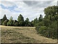
2
North West Edge of Hailes Abbey
House and field by North West Edge of Hailes Abbey
Image: © Shaun Ferguson
Taken: 9 Apr 2008
0.04 miles
3
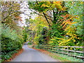
Salter's Lane 1
Colourful view south-west towards Little Farmcote.
Image: © Jonathan Billinger
Taken: 22 Oct 2009
0.05 miles
4
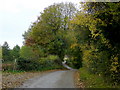
Salter's Lane 2
Looking north-east towards Hailes at the base of the Cotswold scarp.
This is part of the ancient Droitwich to Lechlade Salt Way.
Image: © Jonathan Billinger
Taken: 22 Oct 2009
0.05 miles
5
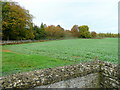
Arable land west of Hailes church
Looking west from the corner of the tiny churchyard over a crop of rape towards the beeches lining the lane to Hailes.
Image: © Jonathan Billinger
Taken: 22 Oct 2009
0.05 miles
6
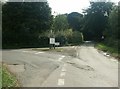
Road junction, Hailes
Salter's Lane ahead; dead-end towards Hailes Abbey and Hayles Fruit Farm to the left. Looking at the paper 1:25k map for a wider overview, Salter's Lane seems to be part of the Salt Way, the historic route taken by mule trains bringing salt from mines in Droitwich to the Thames at Lechlade for transport to London. (http://www.cotswolds.info/blogs/tracks-and-roads.shtml , http://tinyurl.com/kvdfc )
Image: © Katy Walters
Taken: 14 Aug 2006
0.06 miles
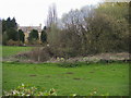
7
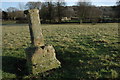
Hailes Abbey
Possibly the remains of a cross situated to the west of Hailes Abbey which can be seen in the background.
Image: © Philip Halling
Taken: 23 Dec 2007
0.06 miles
8

The Cotswold Way towards Salter's Lane
The Cotswold Way, day one 3:44pm
Image: © Ian S
Taken: 17 Apr 2013
0.07 miles
10
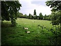
Field adjacent to Hailes Abbey, looking towards Hailes House
Image: © David Gearing
Taken: 12 Jul 2011
0.07 miles