IMAGES TAKEN NEAR TO
Winchcombe, CHELTENHAM, GL54 5LS
Introduction
This page details the photographs taken nearby to GL54 5LS by members of the Geograph project.
The Geograph project started in 2005 with the aim of publishing, organising and preserving representative images for every square kilometre of Great Britain, Ireland and the Isle of Man.

There are currently over 7.5m images from over14,400 individuals and you can help contribute to the project by visiting https://www.geograph.org.uk
Image Map
Images are licensed for reuse under creativecommons.org/licenses/by-sa/2.0
Notes
- Clicking on the map will re-center to the selected point.
- The higher the marker number, the further away the image location is from the centre of the postcode.
Image Listing (422 Images Found)
Images are licensed for reuse under creativecommons.org/licenses/by-sa/2.0
Image
Details
Distance
1
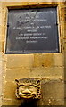
Chandos Almshouses plaque and gargoyle, Winchcombe
On this http://www.geograph.org.uk/photo/4423070 building. MDLXXIII is 1573. MDCCCXLI is 1841.
Image: © Jaggery
Taken: 5 Apr 2015
0.01 miles
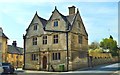
2
House of gables
A compact and delightful house in Winchcombe.
Image: © Colin Craig
Taken: 31 Jul 2009
0.01 miles
3
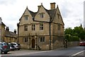
Former King's Grammar School, 1618
Now known as Jacobean House.
Image: © Philip Pankhurst
Taken: 15 Apr 2015
0.01 miles
4
Jacobean House
On Queens Square, built as a school, now residential
Image: © Kevin Waterhouse
Taken: 3 Jul 2021
0.01 miles
5
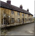
Chandos Almshouses, Winchcombe
In Mill Lane, viewed from the edge of Queens Square.
A plaque http://www.geograph.org.uk/photo/4423078 records that the almshouses were founded by Lady Dorothy Chandos of Sudeley Castle
about the year MDLXXIII (1573) and nearly rebuilt by voluntary contributions in MDCCCXLI (1841).
Image: © Jaggery
Taken: 5 Apr 2015
0.01 miles
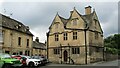
6

Dent's Terrace
A fine group of almshouses, the work of George Gilbert Scott in 1865.
Image: © Philip Pankhurst
Taken: 15 Apr 2015
0.01 miles
7
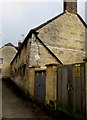
Almshouses electricity substation, Winchcombe
The Central Networks electricity substation in Mill Lane is next to the Chandos Almshouses. http://www.geograph.org.uk/photo/4423070
Image: © Jaggery
Taken: 5 Apr 2015
0.01 miles

9
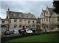
Queens Square, Winchcombe
View from the churchyard at the east end of the church.
Image: © Andrew Hill
Taken: 4 Oct 2013
0.02 miles
10
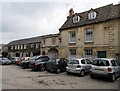
Queens Square parking area, Winchcombe
Queens Square is between Gloucester Street to the west and Abbey Terrace to the east.
Image: © Jaggery
Taken: 5 Apr 2015
0.02 miles