IMAGES TAKEN NEAR TO
Fosse Cross, CHELTENHAM, GL54 4NP
Introduction
This page details the photographs taken nearby to Fosse Cross, GL54 4NP by members of the Geograph project.
The Geograph project started in 2005 with the aim of publishing, organising and preserving representative images for every square kilometre of Great Britain, Ireland and the Isle of Man.

There are currently over 7.5m images from over14,400 individuals and you can help contribute to the project by visiting https://www.geograph.org.uk
Image Map
Images are licensed for reuse under creativecommons.org/licenses/by-sa/2.0
Notes
- Clicking on the map will re-center to the selected point.
- The higher the marker number, the further away the image location is from the centre of the postcode.
Image Listing (5 Images Found)
Images are licensed for reuse under creativecommons.org/licenses/by-sa/2.0
Image
Details
Distance
1
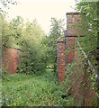
The hamlet of Longfurlong, Foss Cross
This small collection of buildings sit astride a bridleway.
Image: © Brian Robert Marshall
Taken: 29 Dec 2007
0.10 miles
2
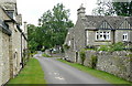
Longfurlong
A hamlet with a number of Cotswold stone houses. It is probably named as the distance from the Fosse Way to the south-east. A furlong is 220 yards, and the distance from the Fosse Way to here is about 300, a long furlong.
Image: © Graham Horn
Taken: 27 Jul 2011
0.11 miles
3
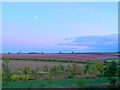
Foss Cross
View west across the grid square from the Fosse Way just south of Foss Cross with the moon well risen as the sun sets.
Image: © Nigel Mykura
Taken: 7 Oct 2011
0.22 miles
4
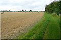
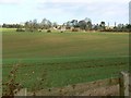
Footpath to Fields Farm
The path runs alongside a large arable field where the crop had been cut and baled but not collected. The path has been diverted around a house to the south and the owner obviously takes pride in that diversion because it has been mown. If he's looking for a compliment, I'll compliment him. Very pleasant to walk on.
Image: © Graham Horn
Taken: 27 Jul 2011
0.23 miles