IMAGES TAKEN NEAR TO
Whittington, CHELTENHAM, GL54 4HF
Introduction
This page details the photographs taken nearby to GL54 4HF by members of the Geograph project.
The Geograph project started in 2005 with the aim of publishing, organising and preserving representative images for every square kilometre of Great Britain, Ireland and the Isle of Man.

There are currently over 7.5m images from over14,400 individuals and you can help contribute to the project by visiting https://www.geograph.org.uk
Image Map (Loading...)


Getting Data...Please wait
Leaflet Map data © OpenStreetMap
Images are licensed for reuse under creativecommons.org/licenses/by-sa/2.0
Notes
- Clicking on the map will re-center to the selected point.
- The higher the marker number, the further away the image location is from the centre of the postcode.
Image Listing (28 Images Found)
Images are licensed for reuse under creativecommons.org/licenses/by-sa/2.0
Image
Details
Distance
1
Sandywell Park
Sandywell Park viewed from the lane to the west.
Image: © Philip Halling
Taken: 5 Dec 2010
0.03 miles
3
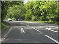
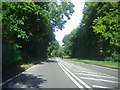
The A40, Whittington
It's very hard to see but there's the junction with the road to Whittington at the end before the bend and a bus stop opposite it on the right.
Image: © David Howard
Taken: 29 Jul 2013
0.19 miles
4

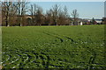
Through the crops
The barely discernible footpath to Syreford passes through these crops.
Image: © Michael Dibb
Taken: 17 Dec 2009
0.20 miles
5
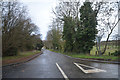
Cotswold : Whitington Court Lane
Looking along a lane off the A40.
Image: © Lewis Clarke
Taken: 18 Mar 2019
0.20 miles
6
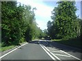
The A40, Whittington
The double white lines and hatching can be seen to have been widened and the lines shifted to the left, as the remains of the old lines can still be seen in the middle of the hatching if you look closely.
Image: © David Howard
Taken: 29 Jul 2013
0.20 miles
7
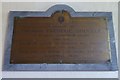
War memorial to Thomas Frederic Colville
War memorial to Thomas Frederic Colville in Whittington church. Aged 20, he was killed in action in Tunisia on 25 December 1942. He was the son of Thomas and Ellen Colville of nearby Sandywell Park.
Image: © Philip Halling
Taken: 24 Aug 2017
0.22 miles
8
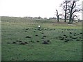
Lumpy field
The footpath to Syreford passes through this field with numerous molehills. These are not the only lumps and bumps in the field, it contains the site of the lost Medieval village of Whittington.
Image: © Michael Dibb
Taken: 17 Dec 2009
0.22 miles
9
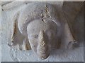
Carved head in Whittington church
A carved head on a pillar in Whittington church.
Image: © Philip Halling
Taken: 24 Aug 2017
0.23 miles
10
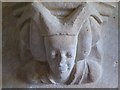
Carving in Whittington church
A carved head on a pillar in Whittington church.
Image: © Philip Halling
Taken: 24 Aug 2017
0.23 miles