IMAGES TAKEN NEAR TO
The Farthings, CHELTENHAM, GL54 4DF
Introduction
This page details the photographs taken nearby to The Farthings, GL54 4DF by members of the Geograph project.
The Geograph project started in 2005 with the aim of publishing, organising and preserving representative images for every square kilometre of Great Britain, Ireland and the Isle of Man.

There are currently over 7.5m images from over14,400 individuals and you can help contribute to the project by visiting https://www.geograph.org.uk
Image Map
Images are licensed for reuse under creativecommons.org/licenses/by-sa/2.0
Notes
- Clicking on the map will re-center to the selected point.
- The higher the marker number, the further away the image location is from the centre of the postcode.
Image Listing (7 Images Found)
Images are licensed for reuse under creativecommons.org/licenses/by-sa/2.0
Image
Details
Distance
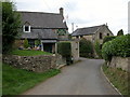
1
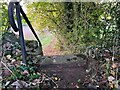
Stone Stile, Withington
On Gloucestershire footpath KWG27 looking North.
The view South is Image
Image: © Jayne Tovey
Taken: 24 Oct 2022
0.13 miles
2
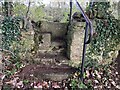
Stone Stile, Withington
On Gloucestershire footpath KWG27 looking South.
The view North is Image
Image: © Jayne Tovey
Taken: 24 Oct 2022
0.13 miles
5
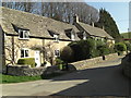
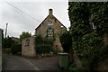
Cotswold stone cottages in Withington
No house names, no road names, just attractive traditional dwellings.
Image: © Stuart Logan
Taken: 28 Mar 2012
0.16 miles
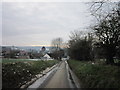
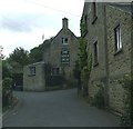
6
The King's Head, Withington
Pub in Withington on the road to Cassey Compton.
Image: © Philip Halling
Taken: 17 Sep 2006
0.16 miles