IMAGES TAKEN NEAR TO
Harnham Lane, CHELTENHAM, GL54 4DD
Introduction
This page details the photographs taken nearby to Harnham Lane, GL54 4DD by members of the Geograph project.
The Geograph project started in 2005 with the aim of publishing, organising and preserving representative images for every square kilometre of Great Britain, Ireland and the Isle of Man.

There are currently over 7.5m images from over14,400 individuals and you can help contribute to the project by visiting https://www.geograph.org.uk
Image Map
Images are licensed for reuse under creativecommons.org/licenses/by-sa/2.0
Notes
- Clicking on the map will re-center to the selected point.
- The higher the marker number, the further away the image location is from the centre of the postcode.
Image Listing (4 Images Found)
Images are licensed for reuse under creativecommons.org/licenses/by-sa/2.0
Image
Details
Distance
2
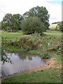
Ford on the river Coln
This ford across the river Coln provides access for the farmer to fields on the other side and is situated below Ravenswell Farm.
Image: © Philip Halling
Taken: 17 Sep 2006
0.22 miles
3
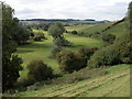
The Coln valley
The river Coln is a tributary of the river Thames. This is a view upstream from SP038161 to the north of the village of Withington. The river is flowing by the trees on the left, though here it is little more than a stream.
Image: © Philip Halling
Taken: 17 Sep 2006
0.23 miles
4
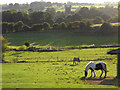
Pastures, Withington
Looking towards the church across the Coln valley from the start of a footpath at the northeast end of the village.
Image: © Andrew Smith
Taken: 20 Sep 2009
0.24 miles