IMAGES TAKEN NEAR TO
Chedworth Road, CHELTENHAM, GL54 4BW
Introduction
This page details the photographs taken nearby to Chedworth Road, GL54 4BW by members of the Geograph project.
The Geograph project started in 2005 with the aim of publishing, organising and preserving representative images for every square kilometre of Great Britain, Ireland and the Isle of Man.

There are currently over 7.5m images from over14,400 individuals and you can help contribute to the project by visiting https://www.geograph.org.uk
Image Map (Loading...)


Getting Data...Please wait
Leaflet Map data © OpenStreetMap
Images are licensed for reuse under creativecommons.org/licenses/by-sa/2.0
Notes
- Clicking on the map will re-center to the selected point.
- The higher the marker number, the further away the image location is from the centre of the postcode.
Image Listing (8 Images Found)
Images are licensed for reuse under creativecommons.org/licenses/by-sa/2.0
Image
Details
Distance
2
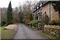
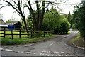
Cottage at Colnbrook, Withington
This cottage situated just outside Withington is by the River Coln, a tributary of the River Thames.
Image: © Philip Halling
Taken: 26 Feb 2006
0.01 miles
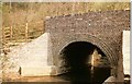
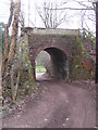
3

Road bridge over River Coln
Bridge after major reconstruction, involving rebuilding walls and wings and repointing arch, by yours truly and colleagues from GCC highways.
Image: © norman hyett
Taken: 29 Mar 1982
0.03 miles
5
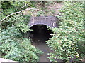
River Coln going under old railway embankment
Image: © norman hyett
Taken: 1 Oct 2009
0.04 miles
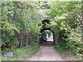
7
Disused railway bridge
This bridge carried the Andoversford to Cirencester line over a track at Woodbridge. This is the other side of the bridge to that photographed by Norman Hyett.
Image: © Terry Jacombs
Taken: 9 Mar 2012
0.10 miles