IMAGES TAKEN NEAR TO
Queen Street, CHELTENHAM, GL54 4AE
Introduction
This page details the photographs taken nearby to Queen Street, GL54 4AE by members of the Geograph project.
The Geograph project started in 2005 with the aim of publishing, organising and preserving representative images for every square kilometre of Great Britain, Ireland and the Isle of Man.

There are currently over 7.5m images from over14,400 individuals and you can help contribute to the project by visiting https://www.geograph.org.uk
Image Map
Images are licensed for reuse under creativecommons.org/licenses/by-sa/2.0
Notes
- Clicking on the map will re-center to the selected point.
- The higher the marker number, the further away the image location is from the centre of the postcode.
Image Listing (166 Images Found)
Images are licensed for reuse under creativecommons.org/licenses/by-sa/2.0
Image
Details
Distance
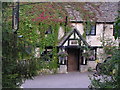
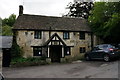
1
The Seven Tuns
This is a Grade II listed building that probably started life as a stable in the early 17th C. Further modifications were carried out about 100 years later. It has English Heritage Building ID: 131092. See also:
http://www.britishlistedbuildings.co.uk/en-131092-the-seven-tuns-chedworth
Image: © Stuart Logan
Taken: 28 Mar 2012
0.00 miles
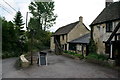
2
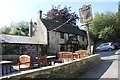
The Seven Tuns, Chedworth
A slightly different view to other photographs of the pub. The Union Jack is displayed in support of the GB Olympic team.
Image: © Terry Jacombs
Taken: 10 Aug 2012
0.00 miles
3
Outside seating, Seven Tuns, Chedworth
Image: © Terry Jacombs
Taken: 10 Aug 2012
0.00 miles
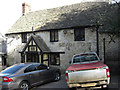
4
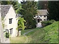
Seven Tuns, Chedworth
Picture taken from the higher road in the village but with a path leading to the front door of the local on the lower road.
Image: © Graham Horn
Taken: 29 Apr 2007
0.01 miles
7
![Chedworth buildings [3]](https://s0.geograph.org.uk/geophotos/06/38/07/6380712_d9d49c49_120x120.jpg)
Chedworth buildings [3]
The Seven Tuns public house is early/mid 17th century, extended late 17th/early 18th century and incorporates a 19th century stable block. Listed, grade II, with details at: https://historicengland.org.uk/listing/the-list/list-entry/1152310
Lower, Middle and Upper Chedworth, without any distinct boundaries, sprawl over more than a mile along and above the broad valley of a tributary of the River Coln which is fed by many copious springs. The village is widely known for its Roman villa, one of the most extensive to be uncovered in England.
Image: © Michael Dibb
Taken: 22 Oct 2019
0.01 miles
8
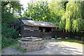
Barbecue and storage building, Seven Tuns, Chedworth
Image: © Terry Jacombs
Taken: 10 Aug 2012
0.01 miles
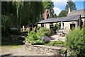
9
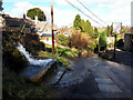
Overflowing trough opposite the Seven Tuns pub
Trough fed by the pond above overflowing after winter storms. See also Image]
Image: © Vieve Forward
Taken: 25 Feb 2022
0.01 miles