IMAGES TAKEN NEAR TO
Furzen Hill, CHELTENHAM, GL54 3QF
Introduction
This page details the photographs taken nearby to Furzen Hill, GL54 3QF by members of the Geograph project.
The Geograph project started in 2005 with the aim of publishing, organising and preserving representative images for every square kilometre of Great Britain, Ireland and the Isle of Man.

There are currently over 7.5m images from over14,400 individuals and you can help contribute to the project by visiting https://www.geograph.org.uk
Image Map
Images are licensed for reuse under creativecommons.org/licenses/by-sa/2.0
Notes
- Clicking on the map will re-center to the selected point.
- The higher the marker number, the further away the image location is from the centre of the postcode.
Image Listing (3 Images Found)
Images are licensed for reuse under creativecommons.org/licenses/by-sa/2.0
Image
Details
Distance
1
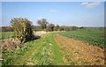
Macmillan Way to Hampnett
Further along footpath KHA 9/2 from Image], again with the wood called The Mine ahead.
Image: © Derek Harper
Taken: 8 Apr 2015
0.19 miles
2
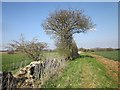
Macmillan Way to Hampnett
Following footpath KHA 9/2 alongside a field boundary. The wood ahead is called The Mine and contains old quarries.
Image: © Derek Harper
Taken: 8 Apr 2015
0.23 miles
3
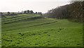
Dry valley, Hampnett
Looking in the opposite direction from the same spot as Image], with striking terraces on the southern slopes near Furzenhill Cottages.
Image: © Derek Harper
Taken: 8 Apr 2015
0.24 miles