IMAGES TAKEN NEAR TO
Barrington Downs, CHELTENHAM, GL54 3PT
Introduction
This page details the photographs taken nearby to Barrington Downs, GL54 3PT by members of the Geograph project.
The Geograph project started in 2005 with the aim of publishing, organising and preserving representative images for every square kilometre of Great Britain, Ireland and the Isle of Man.

There are currently over 7.5m images from over14,400 individuals and you can help contribute to the project by visiting https://www.geograph.org.uk
Image Map
Images are licensed for reuse under creativecommons.org/licenses/by-sa/2.0
Notes
- Clicking on the map will re-center to the selected point.
- The higher the marker number, the further away the image location is from the centre of the postcode.
Image Listing (5 Images Found)
Images are licensed for reuse under creativecommons.org/licenses/by-sa/2.0
Image
Details
Distance
3
Old Milestone by the B4425
Carved stone post by the B4425, in parish of BARRINGTON (COTSWOLD District), East of Barrington; West of Hollowbarn Farm, by the road. Bibury marker, erected by the Bibury & Dancy's Fancy turnpike trust in the 19th century.
Inscription once read:-
(Cirencester)
(13)
(Burford)
(4)
Milestone Society National ID: GL_CIBF13.
Image: © JM Weightmann
Taken: 1 Oct 2000
0.15 miles
4
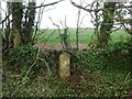
Old Milestone, B4425 nr Aldsworth
Carved stone post by the B4425, in parish of BARRINGTON (COTSWOLD District), East of Barrington; West of Hollowbarn Farm, by the road. Bibury marker, erected by the Bibury & Dancy's Fancy turnpike trust in the 19th century. See an old B&W earlier image Image
Inscription once read: Cirencester 13 / Burford 4
Milestone Society National ID: GL_CIBF13
Image: © Mr Red
Taken: 4 Mar 2022
0.15 miles
5
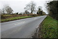
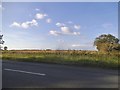
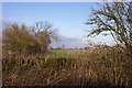
The B4425, Barrington Downs
The B4425 passing Barrington Downs.
Image: © Philip Halling
Taken: 14 Dec 2013
0.23 miles