
IMAGES TAKEN NEAR TO
Sherborne, CHELTENHAM, GL54 3NA
Introduction
This page details the photographs taken nearby to GL54 3NA by members of the Geograph project.
The Geograph project started in 2005 with the aim of publishing, organising and preserving representative images for every square kilometre of Great Britain, Ireland and the Isle of Man.

There are currently over 7.5m images from over14,400 individuals and you can help contribute to the project by visiting https://www.geograph.org.uk
Image Map
Images are licensed for reuse under creativecommons.org/licenses/by-sa/2.0
Notes
- Clicking on the map will re-center to the selected point.
- The higher the marker number, the further away the image location is from the centre of the postcode.
Image Listing (7 Images Found)
Images are licensed for reuse under creativecommons.org/licenses/by-sa/2.0
Image
Details
Distance
1

Cats Abbey Buildings
Self-catering conference centre, with accommodation available for all kinds of groups to hire. https://www.catsabbey.com/
Image: © Vieve Forward
Taken: 12 Sep 2021
0.02 miles
2
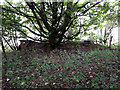
RAF Windrush Stanton air raid shelter near Cats Abbey Buildings
An outlying Stanton shelter (e37074) relating to RAF Windrush. See also Image
Image: © Vieve Forward
Taken: 12 Sep 2021
0.18 miles
3
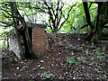
RAF Windrush Stanton air raid shelter near Cats Abbey Buildings
Entrance to Stanton shelter, see also Image
Image: © Vieve Forward
Taken: 12 Sep 2021
0.18 miles
4
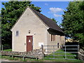
Telephone Exchange, Sherborne, Glos
Built of Cotswold Stone, it is situated on the road to Sherborne, just North of the A40 Main Road, and was previously named Windrush. It has the code SSWRH, and now provides telephone and broadband services to 440 residential and 35 non-residential premises in that village plus Aldsworth, Great Barrington, Little Barrington and Sherborne nearby. The numbering range of this TE is (01451) 844xxx, the (01451) referring to the Stow-on-the-Wold group of five TEs, and its postcode is GL54 3NA.
Image: © David Hillas
Taken: 26 Jul 2008
0.18 miles
5

National Trust Sign near Sherborne
Taken on the A40 road at the junction with the road to Sherborne, this National Truast sign is at the South East boundary of the Sherborne Park Estate. That estate comprises of farmland and woodland with views over the Windrush valley. It was acquired by the National Trust in 1987 and is open all the year round from dawn to dusk.
Image: © David Hillas
Taken: 9 Jun 2015
0.24 miles

7
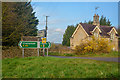
Cotswold : Tight Lane
Looking across to Tight Lane from the A40.
Image: © Lewis Clarke
Taken: 18 Mar 2019
0.24 miles