IMAGES TAKEN NEAR TO
Dutton Leys, CHELTENHAM, GL54 3EN
Introduction
This page details the photographs taken nearby to Dutton Leys, GL54 3EN by members of the Geograph project.
The Geograph project started in 2005 with the aim of publishing, organising and preserving representative images for every square kilometre of Great Britain, Ireland and the Isle of Man.

There are currently over 7.5m images from over14,400 individuals and you can help contribute to the project by visiting https://www.geograph.org.uk
Image Map
Images are licensed for reuse under creativecommons.org/licenses/by-sa/2.0
Notes
- Clicking on the map will re-center to the selected point.
- The higher the marker number, the further away the image location is from the centre of the postcode.
Image Listing (75 Images Found)
Images are licensed for reuse under creativecommons.org/licenses/by-sa/2.0
Image
Details
Distance
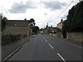
2
Northleach, 1994: High Street
View west, entering the town on the former main road (A40) from Burford, Witney, Oxford and London, for which a by-pass had long since been provided around Northleach.
Image: © Ben Brooksbank
Taken: 13 Jun 1994
0.07 miles
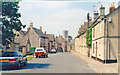
3
Eastington Road at the junction of East End
Image: © David Howard
Taken: 17 Sep 2017
0.10 miles
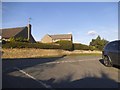
5
![A circular walk around Northleach [4]](https://s3.geograph.org.uk/geophotos/07/34/13/7341315_47fc0138_120x120.jpg)
A circular walk around Northleach [4]
Looking back along the path to the town.
The route heads south from Northleach before heading west to Winterwell Barn and across the Fosse Way. The way is then north towards the picturesque village of Hampnett where the route turns east to run alongside the A40 road before a turn to the south to return to Northleach. Just over 4½ miles.
Image: © Michael Dibb
Taken: 13 Jul 2022
0.11 miles
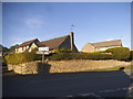
6
![A circular walk around Northleach [2]](https://s1.geograph.org.uk/geophotos/07/34/13/7341313_1c16eca1_120x120.jpg)
A circular walk around Northleach [2]
In King George's Fields are tennis courts and this play area.
The route heads south from Northleach before heading west to Winterwell Barn and across the Fosse Way. The way is then north towards the picturesque village of Hampnett where the route turns east to run alongside the A40 road before a turn to the south to return to Northleach. Just over 4½ miles.
Image: © Michael Dibb
Taken: 13 Jul 2022
0.11 miles
7
Milestone, High St, Northleach
In a corner between Fawley House and a covered vehicular entrance. The plate is missing but going on what can be found, at say http://www.geograph.org.uk/photo/6666948 , it would most likely have read:
Gloster 20 / Oxford 26
Milestone Society National ID: GL_AVBF06
Image: © Mr Red
Taken: 11 Dec 2020
0.11 miles
8
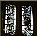
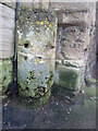
Northleach, SS Peter and Paul Church: Medieval glass fragments 3
Image: © Michael Garlick
Taken: 8 Jun 2017
0.12 miles
9
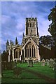
Church of St Peter and St Paul, Northleach, Cotswolds
The Church of St Peter and St Paul in Northleach is known as "The Cathedral of the Cotswolds". The Church as we know it dates from the early 12th century, and was built on top on an even earlier building, also believed to have been a church. The 12th century version of Northleach Church was a fairly simple one, basically consisting of the aisle and not much else. That the chancels were a later addition is immediately apparent from the South Eastern 'quoins' visible in the 'Bicknell' Chapel.
Other things changed too, and we know from the scar on the steeply pitched roof of the tower wall that the south aisle was widened twice. The chancel was built in the 1300's, followed by the nave, aisles and sacristy in the 1400's. The overall style of the present church is known as the Late Medieval "Glass Cage" type in which the structure of the church is of less importance than the large, traceried stained-glass windows.
Image: © Christine Matthews
Taken: Unknown
0.12 miles
10
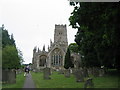
Northleach: Parish Church of St Peter and St Paul
View of eastern end of church
Image: © Nick Robinson
Taken: 31 Jul 2005
0.12 miles